File:Kent Administrative Map 1832.png

Size of this preview: 800 × 516 pixels. Other resolutions: 320 × 206 pixels | 640 × 412 pixels | 1,024 × 660 pixels | 1,280 × 825 pixels | 2,500 × 1,611 pixels.
Original file (2,500 × 1,611 pixels, file size: 803 KB, MIME type: image/png)
Captions
Captions
Add a one-line explanation of what this file represents
Summary edit
| Description |
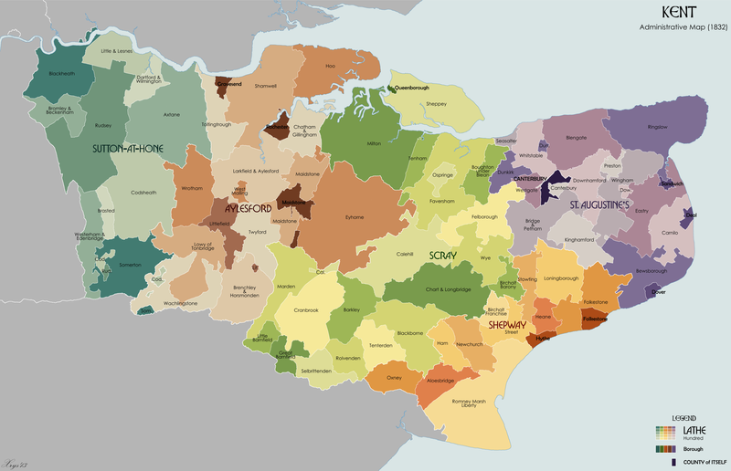
English: Administrative map of the ancient county of Kent in 1832. Showing Lathes, Hundreds, Boroughs and the County of Itself of Canterbury. Source data on parish boundaries - Kain, R.J.P., and Oliver, R.R. (2001) "Historic parishes of England and Wales: Electronic Map - Gazetteer - Metadata", Colchester: History Data Service. ISBN 0 9540032 0 9. Source data for Boroughs: H.M.S.O. Boundary Commission Report 1832 (courtesy of www.visionofbritain.org). |
| Date | |
| Source | Own work |
| Author | XrysD |
Licensing edit
I, the copyright holder of this work, hereby publish it under the following license:
This file is licensed under the Creative Commons Attribution-Share Alike 3.0 Unported license.
- You are free:
- to share – to copy, distribute and transmit the work
- to remix – to adapt the work
- Under the following conditions:
- attribution – You must give appropriate credit, provide a link to the license, and indicate if changes were made. You may do so in any reasonable manner, but not in any way that suggests the licensor endorses you or your use.
- share alike – If you remix, transform, or build upon the material, you must distribute your contributions under the same or compatible license as the original.
File history
Click on a date/time to view the file as it appeared at that time.
| Date/Time | Thumbnail | Dimensions | User | Comment | |
|---|---|---|---|---|---|
| current | 12:22, 9 March 2013 | | 2,500 × 1,611 (803 KB) | XrysD (talk | contribs) | User created page with UploadWizard |
You cannot overwrite this file.
File usage on Commons
The following page uses this file:
File usage on other wikis
The following other wikis use this file:
- Usage on ca.wikipedia.org
- Usage on en.wikipedia.org