File:Kent and East Sussex Railway - geograph.org.uk - 388902.jpg
No higher resolution available.
Kent_and_East_Sussex_Railway_-_geograph.org.uk_-_388902.jpg (640 × 465 pixels, file size: 120 KB, MIME type: image/jpeg)
Captions
Captions
Add a one-line explanation of what this file represents
Summary
edit
| Description |
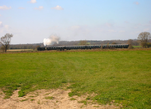
English: Kent and East Sussex Railway A steam train crosses the Rother Levels between Hexden Channel and the River Rother travelling from Wittersham Road to Northiam. Built as a light railway in 1896 the line from Robertsbridge to Headcorn maintained its independence up to 1948. However, it lost its passenger service from 1954 and was officially closed in 1961. A preservation society was formed and after 13 years battle finally reopened the line, albeit from Tenterden to Rolvenden only. The KESR's success has meant gradual extensions, Wittersham Road was reached in 1977, Northiam in 1990 and Bodiam in 2000. |
| Date | |
| Source | From geograph.org.uk |
| Author | Simon Carey |
| Attribution (required by the license) | Simon Carey / Kent and East Sussex Railway / |
| Camera location | | View this and other nearby images on: OpenStreetMap |
|---|
_heading:315.00&language=en)
| Object location | | View this and other nearby images on: OpenStreetMap |
|---|
_heading:315.00&language=en)
Licensing
edit

|
This image was taken from the Geograph project collection. See this photograph's page on the Geograph website for the photographer's contact details. The copyright on this image is owned by Simon Carey and is licensed for reuse under the Creative Commons Attribution-ShareAlike 2.0 license.
|
This file is licensed under the Creative Commons Attribution-Share Alike 2.0 Generic license.
Attribution: Simon Carey
- You are free:
- to share – to copy, distribute and transmit the work
- to remix – to adapt the work
- Under the following conditions:
- attribution – You must give appropriate credit, provide a link to the license, and indicate if changes were made. You may do so in any reasonable manner, but not in any way that suggests the licensor endorses you or your use.
- share alike – If you remix, transform, or build upon the material, you must distribute your contributions under the same or compatible license as the original.
File history
Click on a date/time to view the file as it appeared at that time.
| Date/Time | Thumbnail | Dimensions | User | Comment | |
|---|---|---|---|---|---|
| current | 14:13, 3 February 2011 | | 640 × 465 (120 KB) | GeographBot (talk | contribs) | == {{int:filedesc}} == {{Information |description={{en|1=Kent and East Sussex Railway A steam train crosses the Rother Levels between Hexden Channel and the River Rother travelling from Wittersham Road to Northiam. Built as a light railway in 1896 the lin |
You cannot overwrite this file.
File usage on Commons
There are no pages that use this file.