File:Kentucky (1912–1939) county map, cb 500k.svg

Size of this PNG preview of this SVG file: 800 × 353 pixels. Other resolutions: 320 × 141 pixels | 640 × 282 pixels | 1,024 × 451 pixels | 1,280 × 564 pixels | 2,560 × 1,128 pixels | 810 × 357 pixels.
Original file (SVG file, nominally 810 × 357 pixels, file size: 83 KB)
Captions
Captions
Add a one-line explanation of what this file represents
Summary
edit_county_map,_cb_500k.svg&action=edit§ion=1)
| Description |
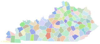
English: A map of the Kentucky counties as they appeared between March 1912 (creation of McCreary) and December 1939 (change in the border between Cumberland and Metcalfe). |
| Date | |
| Source |
This file was derived from: Kentucky county map, cb 500k.svg |
| Author | Original work by User:Awmcphee. This version by User:Mad Mismagius. |
Licensing
edit_county_map,_cb_500k.svg&action=edit§ion=2)
| This file is made available under the Creative Commons CC0 1.0 Universal Public Domain Dedication. | |
| The person who associated a work with this deed has dedicated the work to the public domain by waiving all of their rights to the work worldwide under copyright law, including all related and neighboring rights, to the extent allowed by law. You can copy, modify, distribute and perform the work, even for commercial purposes, all without asking permission.
|
File history
Click on a date/time to view the file as it appeared at that time.
| Date/Time | Thumbnail | Dimensions | User | Comment | |
|---|---|---|---|---|---|
| current | 07:46, 20 July 2023 | | 810 × 357 (83 KB) | Mad Mismagius (talk | contribs) | Uploaded a work by Original work by User:Awmcphee. This version by User:Mad Mismagius. from derivative with UploadWizard |
You cannot overwrite this file.
File usage on Commons
There are no pages that use this file.
_county_map,_cb_500k.svg&oldid=785045278)