File:Kern River Preserve and area map.jpg

Size of this preview: 476 × 600 pixels. Other resolutions: 190 × 240 pixels | 381 × 480 pixels | 924 × 1,164 pixels.
Original file (924 × 1,164 pixels, file size: 245 KB, MIME type: image/jpeg)
Captions
Captions
Add a one-line explanation of what this file represents
Summary
edit| Description |
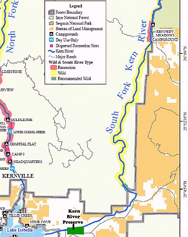
English: The Kern River Nature Preserve map - showing Lake Isabella and the North and South forks of the Kern River.
|
||||||
| Date | Unknown date | ||||||
| Source | http://www.fs.fed.us/r5/sequoia/maps/maps/kern.pdf | ||||||
| Author | USFS | ||||||
| Permission (Reusing this file) |
|
||||||

File history
Click on a date/time to view the file as it appeared at that time.
| Date/Time | Thumbnail | Dimensions | User | Comment | |
|---|---|---|---|---|---|
| current | 04:50, 5 February 2010 | | 924 × 1,164 (245 KB) | Marcia Wright~commonswiki (talk | contribs) | {{Information |Description={{en|1=A screen capture of a PDF map showing Lake Isabella and the North and South forks of the Kern River. Kern County, California US Category:Protected areas Category:Nature reserves of California [[Category:Kern Coun |
You cannot overwrite this file.
File usage on Commons
There are no pages that use this file.