File:KholmGovernorate1913MapPOL.png

Size of this preview: 358 × 598 pixels. Other resolutions: 143 × 240 pixels | 633 × 1,058 pixels.
Original file (633 × 1,058 pixels, file size: 150 KB, MIME type: image/png)
Captions
Captions
Add a one-line explanation of what this file represents
Summary edit
| Description |
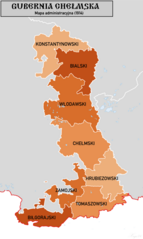
English: English: Polish Language Map of the Kholm Governorate of the Russian Empire in 1914 showing districts. Source Map Data: Специальная карта европейской России (1:420k), Ubersichtskarte von Mitteleuropa (1:300k), Mapa Krolestwa Polskiego (1:504k), courtesy of www.mapywig.com |
| Date | |
| Source | Own work |
| Author | XrysD |
| Other versions |
  |
Licensing edit
I, the copyright holder of this work, hereby publish it under the following license:
This file is licensed under the Creative Commons Attribution-Share Alike 4.0 International license.
- You are free:
- to share – to copy, distribute and transmit the work
- to remix – to adapt the work
- Under the following conditions:
- attribution – You must give appropriate credit, provide a link to the license, and indicate if changes were made. You may do so in any reasonable manner, but not in any way that suggests the licensor endorses you or your use.
- share alike – If you remix, transform, or build upon the material, you must distribute your contributions under the same or compatible license as the original.
File history
Click on a date/time to view the file as it appeared at that time.
| Date/Time | Thumbnail | Dimensions | User | Comment | |
|---|---|---|---|---|---|
| current | 11:51, 20 October 2018 | | 633 × 1,058 (150 KB) | XrysD (talk | contribs) | User created page with UploadWizard |
You cannot overwrite this file.
File usage on Commons
The following 3 pages use this file:
File usage on other wikis
The following other wikis use this file:
- Usage on pl.wikipedia.org