File:Kilimanjaro Region, EO-1 ALI satellite image.jpg

Size of this preview: 515 × 599 pixels. Other resolutions: 206 × 240 pixels | 412 × 480 pixels | 660 × 768 pixels | 880 × 1,024 pixels | 1,760 × 2,048 pixels | 2,936 × 3,416 pixels.
Original file (2,936 × 3,416 pixels, file size: 5.99 MB, MIME type: image/jpeg)
Captions
Captions
Add a one-line explanation of what this file represents
Summary
edit| Description |
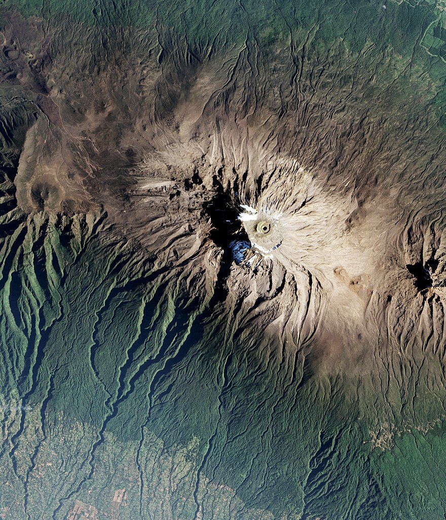
English: The Mt. Kilimanjaro snowcap is seen in this January 2017 image taken by the Pathfinder Earth Observing-1 (EO-1) satellite just months before the mission ended. Originally designed to last one year, EO-1 spent 17 years in orbit providing a variety of Earth data, including observations of forest cover, crops, coastal waters and aerosols. One of EO-1’s most important achievements was to validate the Advanced Land Imager (ALI), which influenced the development of later Earth-observing technologies—including the Operational Land Imager (OLI) on Landsat 8, a NASAU. |
| Date | |
| Source | |
| Author | NASA’s Earth Observatory |
| Other versions |
|

Licensing
edit
| This file is in the public domain in the United States because it was solely created by NASA. NASA copyright policy states that "NASA material is not protected by copyright unless noted". (See Template:PD-USGov, NASA copyright policy page or JPL Image Use Policy.) | ||
 |
Warnings:
|
File history
Click on a date/time to view the file as it appeared at that time.
| Date/Time | Thumbnail | Dimensions | User | Comment | |
|---|---|---|---|---|---|
| current | 21:26, 12 February 2022 | | 2,936 × 3,416 (5.99 MB) | Ras67 (talk | contribs) | losslessly cropped with Jpegcrop |
| 21:25, 12 February 2022 |  | 3,000 × 5,000 (8.67 MB) | Ras67 (talk | contribs) | == {{int:filedesc}} == {{Information |Description = {{en|1=The Mt. Kilimanjaro snowcap is seen in this January 2017 image taken by the Pathfinder Earth Observing-1 (EO-1) satellite just months before the mission ended. Originally designed to last one year, EO-1 spent 17 years in orbit providing a variety of Earth data, including observations of forest cover, crops, coastal waters and aerosols. One of EO-1’s most important achievements was to validate the Advanced Land Imager (ALI), which i... |
You cannot overwrite this file.
File usage on Commons
The following 2 pages use this file: