File:Kinaston Street re-appears - geograph.org.uk - 1433416.jpg
No higher resolution available.
Kinaston_Street_re-appears_-_geograph.org.uk_-_1433416.jpg (640 × 480 pixels, file size: 185 KB, MIME type: image/jpeg)
Captions
Captions
Add a one-line explanation of what this file represents
Summary
edit
| Description |
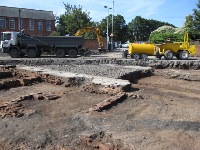
English: Kinaston Street re-appears Looking from St Martins Way across the remains of Kinaston Street. In the 1960s and 1970s this area was cleared, in part to make way for the inner ring road, which is behind the camera. Now the site is to be redeveloped and it is being excavated. The camera angle is looking diagonally across the cobbled street, which, according to the 1851 census, only had 7 houses on each side. Notably the street is cobbled, unlike the nearby Oulton Place, which has the more even stone sets.
As far as I can ascertain Kinaston Street (later Kynaston Street) first appeared on the 1851 census and one of the residents was a George Kinaston (junior). George Kinaston (senior), a 'Fringe Maker', lived in the adjacent St Anne's Street. I don't know if that family had any involvement in the development or naming of the street, but it seems possible. |
| Date | |
| Source | From geograph.org.uk |
| Author | John S Turner |
| Attribution (required by the license) | John S Turner / Kinaston Street re-appears / |
| Camera location | | View this and other nearby images on: OpenStreetMap |
|---|
_heading:225.00&language=en)
| Object location | | View this and other nearby images on: OpenStreetMap |
|---|
_heading:225.00&language=en)
Licensing
edit

|
This image was taken from the Geograph project collection. See this photograph's page on the Geograph website for the photographer's contact details. The copyright on this image is owned by John S Turner and is licensed for reuse under the Creative Commons Attribution-ShareAlike 2.0 license.
|
This file is licensed under the Creative Commons Attribution-Share Alike 2.0 Generic license.
Attribution: John S Turner
- You are free:
- to share – to copy, distribute and transmit the work
- to remix – to adapt the work
- Under the following conditions:
- attribution – You must give appropriate credit, provide a link to the license, and indicate if changes were made. You may do so in any reasonable manner, but not in any way that suggests the licensor endorses you or your use.
- share alike – If you remix, transform, or build upon the material, you must distribute your contributions under the same or compatible license as the original.
File history
Click on a date/time to view the file as it appeared at that time.
| Date/Time | Thumbnail | Dimensions | User | Comment | |
|---|---|---|---|---|---|
| current | 23:00, 1 March 2011 | | 640 × 480 (185 KB) | GeographBot (talk | contribs) | == {{int:filedesc}} == {{Information |description={{en|1=Kinaston Street re-appears Looking from St Martins Way across the remains of Kinaston Street. In the 1960s and 1970s this area was cleared, in part to make way for the inner ring road, which is behi |
You cannot overwrite this file.
File usage on Commons
There are no pages that use this file.