File:King's County, Richmond County.) NYPL1406914.tiff

Size of this JPG preview of this TIF file: 413 × 600 pixels. Other resolutions: 165 × 240 pixels | 330 × 480 pixels | 921 × 1,338 pixels.
Original file (921 × 1,338 pixels, file size: 3.54 MB, MIME type: image/tiff)
Captions
Captions
Add a one-line explanation of what this file represents
Summary edit
| Description | [King's County, Richmond County.]; Atlases of the United States / New York / Atlas of New York. | |||||||||||||||||||||||
| Notes | Map produced by unknown printing process that appears as white on black background. ''Note 2.'') Relief shown by hachures. ''Note 3.'') Title from text on facing p. | |||||||||||||||||||||||
| Catalogue call number | Map Div.02-232 ([Map 2], facing p. 70) | |||||||||||||||||||||||
| Item physical description | 1 map ; 10 x 7 cm. | |||||||||||||||||||||||
| Date | ||||||||||||||||||||||||
| Source |
http://digitalgallery.nypl.org/nypldigital/dgkeysearchdetail.cfm?imageID=1406914
|
|||||||||||||||||||||||
| Author | David H., 1803-1875 -- Cartographer Burr | |||||||||||||||||||||||
| Permission (Reusing this file) |
From The Lionel Pincus and Princess Firyal Map Division. http://maps.nypl.org
|
|||||||||||||||||||||||
| Source description | 99 p. : maps (1 col. fold.) ; 22 cm. | |||||||||||||||||||||||
| Location | Stephen A. Schwarzman Building / The Lionel Pincus and Princess Firyal Map Division | |||||||||||||||||||||||
| Digital item published | 2-3-2004; updated 3-25-2011 | |||||||||||||||||||||||
| Digital ID | 1406914 | |||||||||||||||||||||||

The making of this file was supported by Wikimedia UK.
To see other files made with the support of Wikimedia UK, please see the category Supported by Wikimedia UK.
|
File history
Click on a date/time to view the file as it appeared at that time.
| Date/Time | Thumbnail | Dimensions | User | Comment | |
|---|---|---|---|---|---|
| current | 01:30, 2 May 2014 | 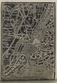 | 921 × 1,338 (3.54 MB) | Fæ (talk | contribs) | GWToolset:: Creating mediafile for Fæ. Tranche 3 7900-11574 (restart) @ 1 May, 12:43 BST |
You cannot overwrite this file.
File usage on Commons
There are no pages that use this file.