File:Kingdom of Hungary counties.svg

Size of this PNG preview of this SVG file: 779 × 513 pixels. Other resolutions: 320 × 211 pixels | 640 × 421 pixels | 1,024 × 674 pixels | 1,280 × 843 pixels | 2,560 × 1,686 pixels.
Original file (SVG file, nominally 779 × 513 pixels, file size: 235 KB)
Captions
Captions
Add a one-line explanation of what this file represents
Summary edit
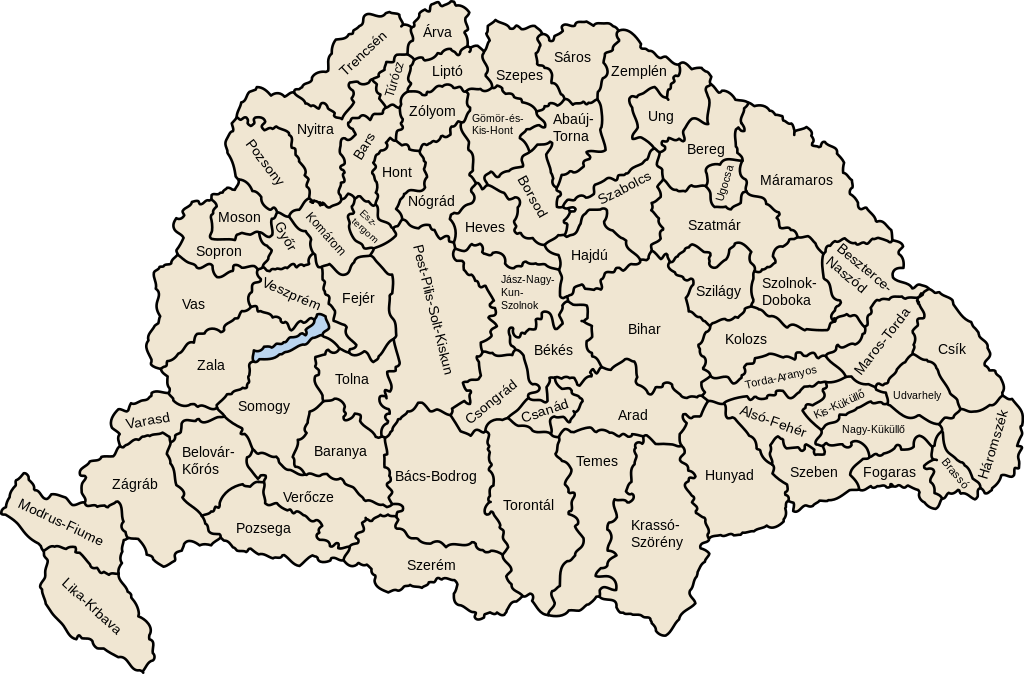
| Description | Map of counties of Kingdom of Hungary (Hungary proper and Croatia & Slavonia), 1886-1918 |
| Date | |
| Source | Own work |
| Author | User:IMeowbot |
| Other versions | Derivative works of this file: Kingdom of Hungary counties-2.svg |
| SVG development | W3C-validity not checked. |
Licensing edit
| I, the copyright holder of this work, release this work into the public domain. This applies worldwide. In some countries this may not be legally possible; if so: I grant anyone the right to use this work for any purpose, without any conditions, unless such conditions are required by law. |
File history
Click on a date/time to view the file as it appeared at that time.
| Date/Time | Thumbnail | Dimensions | User | Comment | |
|---|---|---|---|---|---|
| current | 07:41, 19 July 2023 | | 779 × 513 (235 KB) | Alphathon (talk | contribs) | Reverted to version as of 22:47, 16 August 2022 (UTC). Bars/Hont and Csongrád/Bács-Bodrog borders are inaccurate, several more are distored (most only slightly) and the file is a "FakeSVG" – a raster image using an SVG as a container with no actual vector elements. |
| 22:43, 20 January 2023 |  | 8,277 × 5,472 (589 KB) | Ascended Dreamer (talk | contribs) | Added FIume and increased line weight | |
| 22:31, 20 January 2023 |  | 8,277 × 5,472 (607 KB) | Ascended Dreamer (talk | contribs) | Increased border accuracy | |
| 22:47, 16 August 2022 |  | 779 × 513 (235 KB) | Alphathon (talk | contribs) | corrected õ → ő (tilde → double accute) | |
| 17:53, 5 December 2009 |  | 779 × 513 (235 KB) | SimonTrew (talk | contribs) | Fix spelling error Veszprém. | |
| 14:24, 3 December 2009 |  | 779 × 513 (235 KB) | SimonTrew (talk | contribs) | Fixed spelling of "Poszsony" -> "Pozsony". | |
| 20:25, 20 August 2007 |  | 779 × 513 (235 KB) | Xavax (talk | contribs) | == Summary == {{Information| |Description= Map of counties of Hungary with Croatia & Slavonia, 1886-1918 |Source=own drawing |Date=April 30, 2006 |Author=User:IMeowbot |Permission= |other_versions= }} == Licensing == {{PD-self}} <!--Categories--> [[ | |
| 22:10, 30 April 2006 |  | 779 × 513 (223 KB) | IMeowbot~commonswiki (talk | contribs) | line weight | |
| 21:34, 30 April 2006 |  | 779 × 513 (221 KB) | IMeowbot~commonswiki (talk | contribs) | ||
| 18:34, 30 April 2006 |  | 779 × 513 (195 KB) | IMeowbot~commonswiki (talk | contribs) | {{Information| |Description= Map of late 1870s Hungary counties |Source=own drawing |Date=April 30, 2006 |Author=User:IMeowbot |Permission= |other_versions= }} |
You cannot overwrite this file.
File usage on Commons
The following 40 pages use this file:
- Atlas of Croatia
- Atlas of Hungary
- Atlas of Slovakia
- Atlas of Székely Land
- Magyarország
- File:Historic counties of Hungary.png
- File:Kingdom of Hungary counties-2.svg
- File:Kingdom of Hungary counties (sk).svg
- File:Kingdom of Hungary counties (sk-Abovsko-turnianska).svg
- File:Kingdom of Hungary counties (sk-Aradská).svg
- File:Kingdom of Hungary counties (sk-Baraňská).svg
- File:Kingdom of Hungary counties (sk-Bihárska).svg
- File:Kingdom of Hungary counties (sk-Bjelovarsko-križevetská).svg
- File:Kingdom of Hungary counties (sk-Boršodská).svg
- File:Kingdom of Hungary counties (sk-Brašovská).svg
- File:Kingdom of Hungary counties (sk-Bystricko-nasodská).svg
- File:Kingdom of Hungary counties (sk-Báčsko-bodrodská).svg
- File:Kingdom of Hungary counties (sk-Dolnobelehradská).svg
- File:Kingdom of Hungary counties (sk-Fogarašská).svg
- File:Kingdom of Hungary counties (sk-Gemersko-malohontská).svg
- File:Kingdom of Hungary counties (sk-Hajducká).svg
- File:Kingdom of Hungary counties (sk-Hevešská).svg
- File:Kingdom of Hungary counties (sk-Hontianska).svg
- File:Kingdom of Hungary counties (sk-Huňadská).svg
- File:Kingdom of Hungary counties (sk-Háromsecká).svg
- File:Kingdom of Hungary counties (sk-Jasovsko-veľkokumánsko-solnocká).svg
- File:Kingdom of Hungary counties (sk-Klužská).svg
- File:Kingdom of Hungary counties (sk-Komárňanská).svg
- File:Kingdom of Hungary counties (sk-Krasovsko-severinská).svg
- File:Kingdom of Hungary counties (sk-Licko-krbavská).svg
- File:Kingdom of Hungary counties (sk-Liptovská).svg
- File:Kingdom of Hungary counties (sk-Malokykulská).svg
- File:Kingdom of Hungary counties (sk-Marmarošská).svg
- File:Kingdom of Hungary counties (sk-Marušsko-turdská).svg
- File:Kingdom of Hungary counties (sk-Modrušsko-skorjecká).svg
- File:Kingdom of Hungary counties (sk-Mošonská).svg
- File:Kingdom of Hungary counties (sk-Čanadská).svg
- File:Kingdom of Hungary counties (sk-Čická).svg
- File:Kingdom of Hungary counties (sk-Čongrádska).svg
- File:Kingdom of Hungary counties 1768x1168.png
.svg)
.svg)
.svg)
.svg)
.svg)
.svg)
.svg)
.svg)
.svg)
.svg)
.svg)
.svg)
.svg)
.svg)
.svg)
.svg)
.svg)
.svg)
.svg)
.svg)
.svg)
.svg)
.svg)
.svg)
.svg)
.svg)
.svg)
.svg)
.svg)
.svg)
.svg)
.svg)
File usage on other wikis
The following other wikis use this file:
- Usage on als.wikipedia.org
- Usage on an.wikipedia.org
- Usage on ar.wikipedia.org
- Usage on azb.wikipedia.org
- Usage on bg.wikipedia.org
- Usage on bn.wikipedia.org
- Usage on ca.wikipedia.org
- Usage on cs.wikipedia.org
- Usage on cy.wikipedia.org
- Usage on de.wikipedia.org
- Usage on el.wikipedia.org
- Usage on en.wikipedia.org
- Liptó County
- Zemplén County
- Hont County
- Bars County
- Turóc County
- Brassó County
- Bihar County
- Kingdom of Hungary
- Esztergom County
- Pozsony County
- Nyitra County
- Moson County
- Sopron County
- Bács-Bodrog County
- Heves County (former)
- Jász-Nagykun-Szolnok County (former)
- Trencsén County
- Zólyom County
- Pest-Pilis-Solt-Kiskun County
- Komárom County
- Bereg County
- Borsod County
- Ung County
- Hajdú County
- Máramaros County
- Szabolcs County
- Szatmár County
View more global usage of this file.