File:Kingdom of Lydia.png

Size of this preview: 800 × 446 pixels. Other resolutions: 320 × 179 pixels | 640 × 357 pixels | 1,024 × 571 pixels | 1,280 × 714 pixels | 2,560 × 1,429 pixels | 5,338 × 2,979 pixels.
Original file (5,338 × 2,979 pixels, file size: 3.12 MB, MIME type: image/png)
Captions
Captions
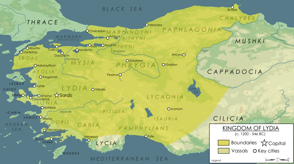
Kingdom of Lydia at it's Greatest Extent
Summary edit
| Description |
English: Map showing the Kingdom of Lydia at it's greatest extent during the late reign of Croesus. Approximate boundaries were determianted by using mainly Herodotus' sources regarding the conquests of Lydian Kings and expanse of the realm. With River Halys seperating the Lydian Kingdom from the Medians. |
| Date | |
| Source | Own work |
| Author | Ennomus |
Licensing edit
I, the copyright holder of this work, hereby publish it under the following license:
This file is licensed under the Creative Commons Attribution-Share Alike 4.0 International license.
- You are free:
- to share – to copy, distribute and transmit the work
- to remix – to adapt the work
- Under the following conditions:
- attribution – You must give appropriate credit, provide a link to the license, and indicate if changes were made. You may do so in any reasonable manner, but not in any way that suggests the licensor endorses you or your use.
- share alike – If you remix, transform, or build upon the material, you must distribute your contributions under the same or compatible license as the original.
File history
Click on a date/time to view the file as it appeared at that time.
| Date/Time | Thumbnail | Dimensions | User | Comment | |
|---|---|---|---|---|---|
| current | 01:45, 21 October 2023 | | 5,338 × 2,979 (3.12 MB) | Ennomus (talk | contribs) | Renewed version of the previous map. |
| 18:55, 20 October 2023 |  | 5,675 × 3,179 (3.27 MB) | Ennomus (talk | contribs) | Uploaded own work with UploadWizard |
You cannot overwrite this file.
File usage on Commons
There are no pages that use this file.
File usage on other wikis
The following other wikis use this file: