File:Kingtons first railway station (geograph 4032486).jpg

Size of this preview: 800 × 536 pixels. Other resolutions: 320 × 214 pixels | 640 × 428 pixels | 1,024 × 685 pixels | 1,280 × 857 pixels | 2,560 × 1,714 pixels | 3,872 × 2,592 pixels.
Original file (3,872 × 2,592 pixels, file size: 4.51 MB, MIME type: image/jpeg)
Captions
Captions
Add a one-line explanation of what this file represents
Summary
edit.jpg&action=edit§ion=1)
| Description |
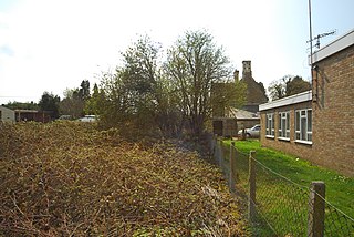
English: Kington's first railway station This - the gabled building in the right background - is the original station building at Kington in Herefordshire, opened by the Great Western Railway in 1857 upon completion of the line from Leominster. I'm standing on the trackbed (or the spot where it used to be), looking towards Kington. By 1875, the railway had been extended to New Radnor and the alignment through Kington was changed, so a new station (now demolished) was built a few yards from here. Freight traffic - which for this area meant sheep, sheep and more sheep - was subsequently handled at the old station site. Nothing remains of the 1875 station building, but the new house constructed on the site has a railway signal mounted on the wall as a reminder of the past use of the land. |
| Date | |
| Source | From geograph.org.uk |
| Author | John Winder |
| Permission (Reusing this file) |
Creative Commons Attribution Share-alike license 2.0 |
| Attribution (required by the license) | John Winder / Kington's first railway station / |
| Camera location | | View this and other nearby images on: OpenStreetMap |
|---|
.jpg¶ms=052.206717_N_-003.020223_E_globe:Earth_type:camera_source:geograph-osgb36(SO30385699)_heading:247.00&language=en)
| Object location | | View this and other nearby images on: OpenStreetMap |
|---|
.jpg¶ms=052.206530_N_-003.020660_E_globe:Earth_class:object_type:object_source:geograph-osgb36(SO30355697)_heading:247.00&language=en)
Licensing
edit.jpg&action=edit§ion=2)

|
This image was taken from the Geograph project collection. See this photograph's page on the Geograph website for the photographer's contact details. The copyright on this image is owned by John Winder and is licensed for reuse under the Creative Commons Attribution-ShareAlike 2.0 license.
|
This file is licensed under the Creative Commons Attribution-Share Alike 2.0 Generic license.
Attribution: John Winder
- You are free:
- to share – to copy, distribute and transmit the work
- to remix – to adapt the work
- Under the following conditions:
- attribution – You must give appropriate credit, provide a link to the license, and indicate if changes were made. You may do so in any reasonable manner, but not in any way that suggests the licensor endorses you or your use.
- share alike – If you remix, transform, or build upon the material, you must distribute your contributions under the same or compatible license as the original.
File history
Click on a date/time to view the file as it appeared at that time.
| Date/Time | Thumbnail | Dimensions | User | Comment | |
|---|---|---|---|---|---|
| current | 23:28, 26 December 2020 | | 3,872 × 2,592 (4.51 MB) | Lamberhurst (talk | contribs) | Transferred from geograph.co.uk using [https://tools.wmflabs.org/geograph2commons/ geograph2commons] |
You cannot overwrite this file.
File usage on Commons
The following page uses this file:
.jpg&oldid=736320722)