File:Kleine Saarschleife.jpg

Size of this preview: 799 × 221 pixels. Other resolutions: 320 × 89 pixels | 640 × 177 pixels | 1,024 × 283 pixels | 1,280 × 354 pixels | 7,225 × 2,000 pixels.
Original file (7,225 × 2,000 pixels, file size: 13.98 MB, MIME type: image/jpeg)
Captions
Captions
Add a one-line explanation of what this file represents
Summary edit
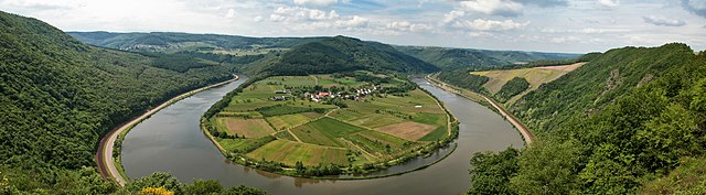
| Description | Kleine Saarschleife bei Hamm |
| Date | |
| Source | Own work |
| Author | Pascal Dihé |
| Attribution (required by the license) | © Pascal Dihé / https://www.dihe.eu / |
| Camera location | | View this and other nearby images on: OpenStreetMap |
|---|
Licensing edit
Pascal Dihé, the copyright holder of this work, hereby publishes it under the following license:
This file is licensed under the Creative Commons Attribution-Share Alike 4.0 International license.
Attribution: Pascal Dihé / www.dihe.eu / CC BY-SA 4.0
- You are free:
- to share – to copy, distribute and transmit the work
- to remix – to adapt the work
- Under the following conditions:
- attribution – You must give appropriate credit, provide a link to the license, and indicate if changes were made. You may do so in any reasonable manner, but not in any way that suggests the licensor endorses you or your use.
- share alike – If you remix, transform, or build upon the material, you must distribute your contributions under the same or compatible license as the original.
File history
Click on a date/time to view the file as it appeared at that time.
| Date/Time | Thumbnail | Dimensions | User | Comment | |
|---|---|---|---|---|---|
| current | 10:04, 10 February 2019 | 7,225 × 2,000 (13.98 MB) | Pascal Dihé (talk | contribs) | replacement with higher resolution version of the same file | |
| 21:59, 31 July 2006 |  | 1,402 × 604 (299 KB) | DrAlzheimer (talk | contribs) | == Beschreibung == {{Information| |Description=Kleine Saarschleife bei Hamm |Source=selbst aufgenommen |Date=siehe EXIF |Author=DrAlzheimer |Permission= GFDL und Creative Commons CC-BY 2.5 }} == Licensing == {{self2|GFDL|cc-by-2.5}} |
You cannot overwrite this file.
File usage on Commons
There are no pages that use this file.
File usage on other wikis
The following other wikis use this file:
- Usage on de.wikipedia.org
- Usage on simple.wikipedia.org
- Usage on uk.wikipedia.org