File:Kołczygłowy (gmina) location map.png

Size of this preview: 315 × 599 pixels. Other resolutions: 126 × 240 pixels | 629 × 1,196 pixels.
Original file (629 × 1,196 pixels, file size: 104 KB, MIME type: image/png)
Captions
Captions
Add a one-line explanation of what this file represents
| Description |
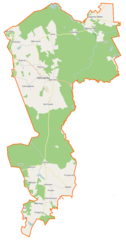
Polski: Mapa gminy Kołczygłowy, Polska
English: Map of Gmina Kołczygłowy, Poland |
|||||||||
| Date | ||||||||||
| Source | You may find a page on the OpenStreetMap wiki page for Kołczygłowy (gmina) | |||||||||
| Creator |
OpenStreetMap contributors OpenStreetMap contributors |
|||||||||
| Permission (Reusing this file) |
OpenStreetMap data is available under the Open Database License (details). Map tiles are licensed under the Creative Commons Attribution-ShareAlike 2.0 license (CC-BY-SA 2.0).
This file is licensed under the Creative Commons Attribution-Share Alike 2.0 Generic license.
|
|||||||||
| Geotemporal data | ||||||||||
| Bounding box |
|
|||||||||
| Georeferencing | If inappropriate please set warp_status = skip to hide. | |||||||||
File history
Click on a date/time to view the file as it appeared at that time.
| Date/Time | Thumbnail | Dimensions | User | Comment | |
|---|---|---|---|---|---|
| current | 15:29, 10 January 2015 | | 629 × 1,196 (104 KB) | VanWiel (talk | contribs) | {{OpenStreetMap | name = Kołczygłowy (gmina) | location = Kołczygłowy (gmina) | description = {{pl|Mapa gminy Kołczygłowy, Polska}} {{en|Map of Gmina Kołczygłowy, Poland}} | top = 54.3173 | bottom... |
You cannot overwrite this file.
File usage on Commons
There are no pages that use this file.
File usage on other wikis
The following other wikis use this file:
- Usage on fr.wikipedia.org
- Kołczygłowy
- Barkocin
- Barnowiec (Poméranie)
- Barnowo (Poméranie)
- Darżkowo
- Dobojewo (Bytów)
- Gałąźnia Mała
- Gałąźnia Wielka
- Gęślice
- Górki (Bytów)
- Grępno
- Jezierze
- Klęskowo (Poméranie)
- Kołczygłówki
- Laski (Bytów)
- Łobzowo (Poméranie)
- Łubno (Poméranie)
- Miłobądź (Poméranie)
- Podgórze (Poméranie)
- Przyborze (Poméranie)
- Pustka (Bytów)
- Radusz (Poméranie)
- Różki
- Sierowo
- Świelubie (Poméranie)
- Wądół (Poméranie)
- Wierszynko
- Wierszyno
- Witanowo
- Zatoki (Poméranie)
- Usage on pl.wikipedia.org
- Kołczygłowy (gmina)
- Barkocin
- Barnowo (województwo pomorskie)
- Darżkowo (powiat bytowski)
- Gałąźnia Mała
- Gałąźnia Wielka
- Jezierze
- Kołczygłowy
- Kołczygłówki
- Łobzowo (województwo pomorskie)
- Łubno (województwo pomorskie)
- Wierszyno
- Witanowo
- Barnowiec (województwo pomorskie)
- Podgórze (województwo pomorskie)
- Przyborze (województwo pomorskie)
- Radusz (województwo pomorskie)
- Wądół (województwo pomorskie)
- Świelubie (województwo pomorskie)
- Górki (powiat bytowski)
View more global usage of this file.
_location_map.png)
_location_map.png&oldid=519971538)