File:Kodiakislandmap.svg

Size of this PNG preview of this SVG file: 701 × 599 pixels. Other resolutions: 281 × 240 pixels | 561 × 480 pixels | 898 × 768 pixels | 1,198 × 1,024 pixels | 2,395 × 2,048 pixels | 1,000 × 855 pixels.
Original file (SVG file, nominally 1,000 × 855 pixels, file size: 850 KB)
Captions
Captions
Add a one-line explanation of what this file represents
Summary edit
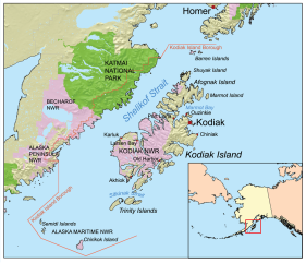
| Description | This map of Kodiak Island and the surrounding area. I, Karl Musser, created it based on USGS data. | ||
| Date | (UTC) | ||
| Source | |||
| Author |
|
||
| SVG development |
|

Licensing edit
I, the copyright holder of this work, hereby publish it under the following license:
This file is licensed under the Creative Commons Attribution-Share Alike 2.5 Generic license.
- You are free:
- to share – to copy, distribute and transmit the work
- to remix – to adapt the work
- Under the following conditions:
- attribution – You must give appropriate credit, provide a link to the license, and indicate if changes were made. You may do so in any reasonable manner, but not in any way that suggests the licensor endorses you or your use.
- share alike – If you remix, transform, or build upon the material, you must distribute your contributions under the same or compatible license as the original.
Original upload log edit
This image is a derivative work of the following images:
- File:Kodiakislandmap.png licensed with Cc-by-sa-2.5
- 2007-03-22T19:32:14Z Kmusser 1000x855 (643787 Bytes) This map of [[:en:Kodiak Island|Kodiak Island]] and the surrounding area. I, [[:en:User:Kmusser|Karl Musser]], created it based on [[:en:USGS|USGS]] data. {{self|cc-by-sa-2.5}} [[Category:SVG maps of Alaska]]
Uploaded with derivativeFX
File history
Click on a date/time to view the file as it appeared at that time.
| Date/Time | Thumbnail | Dimensions | User | Comment | |
|---|---|---|---|---|---|
| current | 02:25, 10 September 2009 | | 1,000 × 855 (850 KB) | Rrburke (talk | contribs) | {{Information |Description=This map of Kodiak Island and the surrounding area. I, Karl Musser, created it based on USGS data. |Source=*File:Kodiakislandmap.png |Date=2009-09-10 02:23 (UTC) |Aut |
You cannot overwrite this file.
File usage on Commons
There are no pages that use this file.