File:Kommunalvalet 1966 största block.png

Size of this preview: 252 × 598 pixels. Other resolutions: 101 × 240 pixels | 202 × 480 pixels | 803 × 1,905 pixels.
Original file (803 × 1,905 pixels, file size: 137 KB, MIME type: image/png)
Captions
Captions
Add a one-line explanation of what this file represents
Summary
edit
| Description |
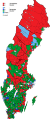
Svenska: Största parti inom det ledande blocket i samtliga 900 kommuners kommun- och stadsfullmäktige efter kommunalvalet 1966. I kommuner där blocken fick lika många mandat ha röstetal avgjort färgen. Grå färg används för Holmöns landskommun där inget av de etablerade partierna hamnade i kommunfullmäktige. |
| Date | |
| Source | Own work |
| Author | Ff152Rr361Af7 |
Licensing
edit
I, the copyright holder of this work, hereby publish it under the following license:
This file is licensed under the Creative Commons Attribution-Share Alike 4.0 International license.
- You are free:
- to share – to copy, distribute and transmit the work
- to remix – to adapt the work
- Under the following conditions:
- attribution – You must give appropriate credit, provide a link to the license, and indicate if changes were made. You may do so in any reasonable manner, but not in any way that suggests the licensor endorses you or your use.
- share alike – If you remix, transform, or build upon the material, you must distribute your contributions under the same or compatible license as the original.
File history
Click on a date/time to view the file as it appeared at that time.
| Date/Time | Thumbnail | Dimensions | User | Comment | |
|---|---|---|---|---|---|
| current | 16:57, 26 December 2018 | | 803 × 1,905 (137 KB) | Ff152Rr361Af7 (talk | contribs) | Gränskorrigeringar. |
| 15:48, 18 July 2018 |  | 803 × 1,905 (137 KB) | Ff152Rr361Af7 (talk | contribs) | Gränskorrigeringar. | |
| 15:32, 23 June 2018 |  | 803 × 1,905 (136 KB) | Ff152Rr361Af7 (talk | contribs) | Korrigering av slarvfel. | |
| 05:23, 5 May 2018 |  | 803 × 1,905 (137 KB) | Ff152Rr361Af7 (talk | contribs) | Ändringar av gräns och färger. | |
| 14:35, 7 April 2018 |  | 803 × 1,905 (134 KB) | Ff152Rr361Af7 (talk | contribs) | Gränsändringar | |
| 13:21, 4 April 2018 |  | 803 × 1,905 (134 KB) | Ff152Rr361Af7 (talk | contribs) | Gränsändringar | |
| 06:00, 20 January 2018 |  | 803 × 1,905 (134 KB) | Ff152Rr361Af7 (talk | contribs) | Gränsändringar | |
| 07:08, 11 December 2016 |  | 803 × 1,905 (134 KB) | Ff152Rr361Af7 (talk | contribs) | Gränsändringar | |
| 10:47, 4 November 2016 |  | 803 × 1,905 (134 KB) | Ff152Rr361Af7 (talk | contribs) | Gränsändringar | |
| 15:34, 25 September 2016 |  | 803 × 1,905 (134 KB) | Ff152Rr361Af7 (talk | contribs) | Gränskorrigering angående Hultsfreds köping |
You cannot overwrite this file.
File usage on Commons
The following 9 pages use this file:
- User:Magog the Ogre/Political maps/2016 December 11-20
- User:Magog the Ogre/Political maps/2016 November 1-10
- User:Magog the Ogre/Political maps/2016 September 21-30
- User:Magog the Ogre/Political maps/2018 April 1-10
- User:Magog the Ogre/Political maps/2018 December 21-31
- User:Magog the Ogre/Political maps/2018 January 11-20
- User:Magog the Ogre/Political maps/2018 July 11-20
- User:Magog the Ogre/Political maps/2018 June 21-30
- User:Magog the Ogre/Political maps/2018 May 1-10
File usage on other wikis
The following other wikis use this file:
- Usage on fi.wikipedia.org
- Usage on sv.wikipedia.org