File:Kongo 1961 map de.png
Size of this preview: 630 × 600 pixels. Other resolutions: 252 × 240 pixels | 504 × 480 pixels | 807 × 768 pixels | 1,075 × 1,024 pixels | 2,032 × 1,935 pixels.
Original file (2,032 × 1,935 pixels, file size: 947 KB, MIME type: image/png)
Captions
Captions
Add a one-line explanation of what this file represents
Summary
edit
| Description |
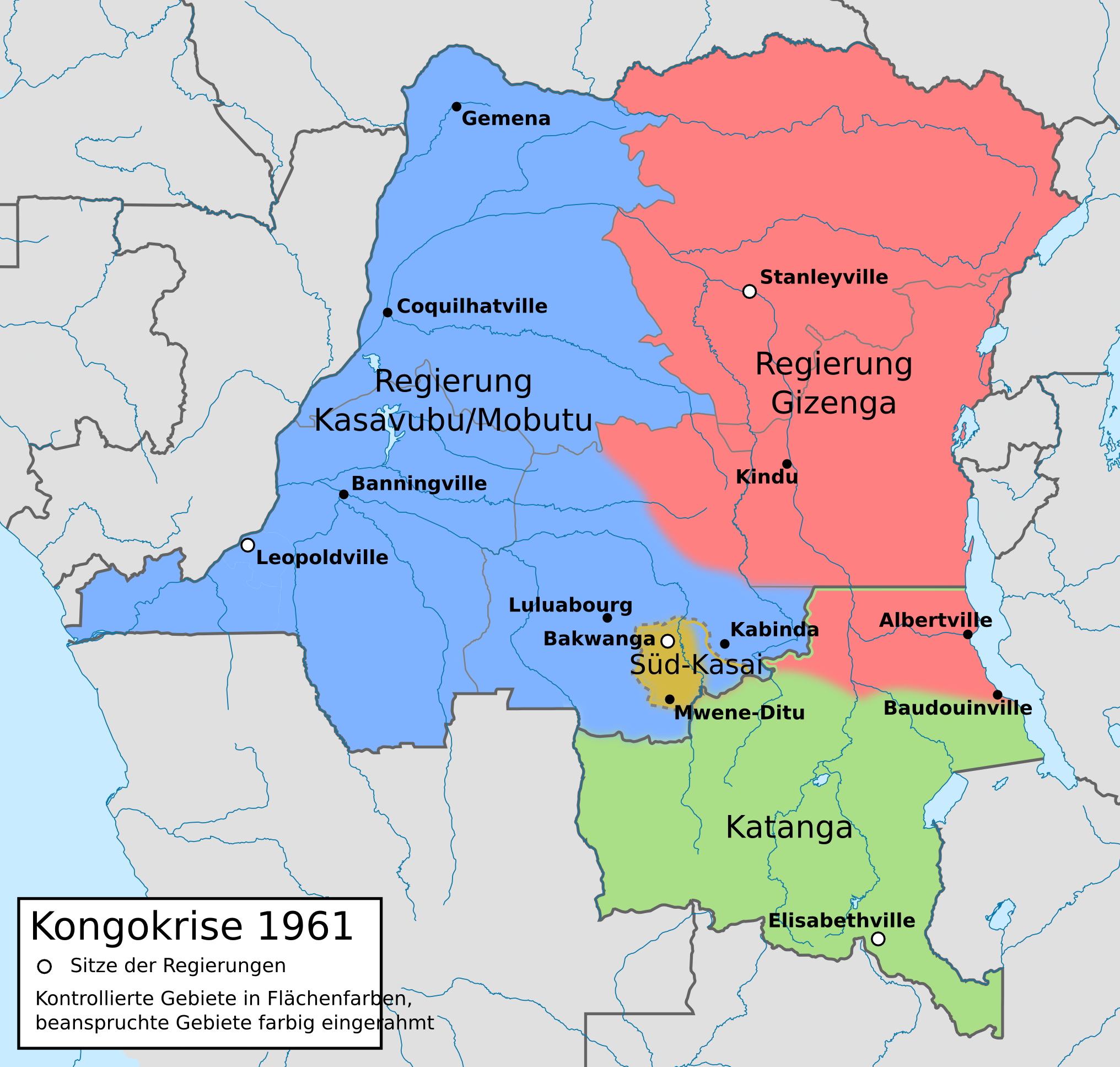
English: Map of Congo in 1961 (Congo crisis), in German.
Deutsch: Karte des Kongo 1961 (Kongo-Krise), auf Deutsch. Quellen:
|
| Date | |
| Source | Own work, based on File:Democratic Republic of the Congo location map.svg |
| Author | Don-kun, Uwe Dedering |
| Other versions |
 |
Licensing
edit
I, the copyright holder of this work, hereby publish it under the following licenses:

|
Permission is granted to copy, distribute and/or modify this document under the terms of the GNU Free Documentation License, Version 1.2 or any later version published by the Free Software Foundation; with no Invariant Sections, no Front-Cover Texts, and no Back-Cover Texts. A copy of the license is included in the section entitled GNU Free Documentation License. |
This file is licensed under the Creative Commons Attribution 3.0 Unported license.
- You are free:
- to share – to copy, distribute and transmit the work
- to remix – to adapt the work
- Under the following conditions:
- attribution – You must give appropriate credit, provide a link to the license, and indicate if changes were made. You may do so in any reasonable manner, but not in any way that suggests the licensor endorses you or your use.
You may select the license of your choice.
File history
Click on a date/time to view the file as it appeared at that time.
| Date/Time | Thumbnail | Dimensions | User | Comment | |
|---|---|---|---|---|---|
| current | 13:58, 12 July 2015 | | 2,032 × 1,935 (947 KB) | Don-kun (talk | contribs) | fix names |
| 21:43, 7 July 2014 |  | 1,687 × 1,606 (558 KB) | RokerHRO (talk | contribs) | optipng -o7 | |
| 15:54, 18 April 2013 |  | 1,687 × 1,606 (736 KB) | Don-kun (talk | contribs) | {{Information |Description ={{en|1=Map of Congo in 1961 (Congo crisis), in German.}} {{de|1=Karte des Kongo 1961 (Kongo-Krise), auf Deutsch. Quellen: * dtv-Atlas Weltgeschichte. 2005. S. 546 f. * Young, Politics in the Congo. 1965. * Kalondji, Congo... |
You cannot overwrite this file.
File usage on Commons
The following page uses this file:
File usage on other wikis
The following other wikis use this file:
- Usage on de.wikipedia.org