File:Koppen-Geiger Map LBN present fr.svg

Size of this PNG preview of this SVG file: 800 × 516 pixels. Other resolutions: 320 × 206 pixels | 640 × 413 pixels | 1,024 × 660 pixels | 1,280 × 825 pixels | 2,560 × 1,651 pixels | 1,318 × 850 pixels.
Original file (SVG file, nominally 1,318 × 850 pixels, file size: 539 KB)
Captions
Captions
Add a one-line explanation of what this file represents
Summary edit
| Description |
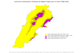
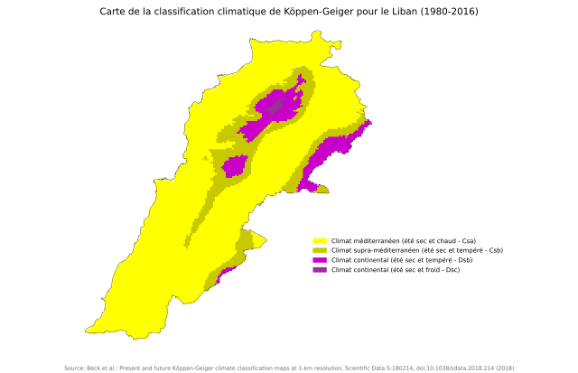
Français : Carte climatique du Liban selon la classification Köppen-Geiger
Climat méditerranéen (été chaud - Csa)
Climat supra-méditerranéen (été tempéré - Csb)
Climat continental (été tempéré - Dsb)
Climat continental (été froid - Dsc) |
| Date | |
| Source | "Present and future Köppen-Geiger climate classification maps at 1-km resolution". Nature Scientific Data. DOI:10.1038/sdata.2018.214. - Traduction de la carte en anglais File:Koppen-Geiger_Map_LBN_present.svg |
| Author | Beck, H.E., Zimmermann, N. E., McVicar, T. R., Vergopolan, N., Berg, A., & Wood, E. F. |
Licensing edit
This file is licensed under the Creative Commons Attribution 4.0 International license.
- You are free:
- to share – to copy, distribute and transmit the work
- to remix – to adapt the work
- Under the following conditions:
- attribution – You must give appropriate credit, provide a link to the license, and indicate if changes were made. You may do so in any reasonable manner, but not in any way that suggests the licensor endorses you or your use.
File history
Click on a date/time to view the file as it appeared at that time.
| Date/Time | Thumbnail | Dimensions | User | Comment | |
|---|---|---|---|---|---|
| current | 21:47, 14 March 2024 | | 1,318 × 850 (539 KB) | BotaFlo (talk | contribs) | correction : le climat Dsc était mal codifié |
| 21:43, 14 March 2024 |  | 1,318 × 850 (539 KB) | BotaFlo (talk | contribs) | Uploaded a work by {{Unknown|author}} from Koppen-Geiger Map LBN present.svg with UploadWizard |
You cannot overwrite this file.
File usage on Commons
The following page uses this file:
File usage on other wikis
The following other wikis use this file:
- Usage on fr.wikipedia.org