File:Koshkarkol Lake ESA365539.jpg

Original file (3,077 × 2,596 pixels, file size: 5.8 MB, MIME type: image/jpeg)
Captions
Captions
Summary edit
| DescriptionKoshkarkol Lake ESA365539.jpg |
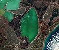
English: Large chunks of broken ice float in east-central Kazakhstan’s Alakol Lake in this Copernicus Sentinel-2 image from 5 April 2016.
This salt lake usually freezes for about two months at the end of winter, and breaks up in early spring – as we can see happening here. The lake’s mineral-rich water and mud is considered to be therapeutic, and tourists often visit the lake’s northern shores to remedy skin ailments. Alakol means ‘multicoloured lake’ – and we can clearly see varying shades of green and blue depending on the depth, sediments flowing in from rivers and streams and phytoplankton. The two smaller, shallower lakes to the northwest are Kosharkol and Sasykkol. The Alakol–Sasykkol lake system is both a Ramsar Wetland of International Importance and a UNESCO Biosphere Reserve. It is an important migratory stop and nesting area for a variety of water birds, including the Dalmatian Pelican and Greater Flamingo. In the lower-left corner of the image we can see agricultural structures in an alluvial fan. The triangular fan is formed when water runoff from the Dzungarian Alatau mountains (not pictured) hits the plain and spreads out, leaving behind fertile soil. This image is featured on the Earth from Space video programme. |
|||
| Date | ||||
| Source | http://www.esa.int/spaceinimages/Images/2016/09/Alakol_Lake | |||
| Author | European Space Agency | |||
| Permission (Reusing this file) |
Contains modified Copernicus Sentinel data (2016), processed by ESA,CC BY-SA 3.0 IGO | |||
| Other versions |
|
|||
| Title InfoField | Alakol Lake | |||
| Set InfoField | Earth observation image of the week | |||
| System InfoField | Copernicus | |||
| Mission InfoField | Sentinel-2 | |||
| Location InfoField | Kazakhstan | |||
| Activity InfoField | Observing the Earth | |||
| Keywords InfoField | Lake; Wetlands; Satellite image |
Licensing edit
- You are free:
- to share – to copy, distribute and transmit the work
- to remix – to adapt the work
- Under the following conditions:
- attribution – You must give appropriate credit, provide a link to the license, and indicate if changes were made. You may do so in any reasonable manner, but not in any way that suggests the licensor endorses you or your use.
- share alike – If you remix, transform, or build upon the material, you must distribute your contributions under the same or compatible license as the original.


|
This image contains data from a satellite in the Copernicus Programme, such as Sentinel-1, Sentinel-2 or Sentinel-3. Attribution is required when using this image.
Attribution: Contains modified Copernicus Sentinel data {{{year}}}
Attribution
The use of Copernicus Sentinel Data is regulated under EU law (Commission Delegated Regulation (EU) No 1159/2013 and Regulation (EU) No 377/2014). Relevant excerpts:
Free access shall be given to GMES dedicated data [...] made available through GMES dissemination platforms [...].
Access to GMES dedicated data [...] shall be given for the purpose of the following use in so far as it is lawful:
GMES dedicated data [...] may be used worldwide without limitations in time.
GMES dedicated data and GMES service information are provided to users without any express or implied warranty, including as regards quality and suitability for any purpose. |
Attribution
File history
Click on a date/time to view the file as it appeared at that time.
| Date/Time | Thumbnail | Dimensions | User | Comment | |
|---|---|---|---|---|---|
| current | 17:46, 15 November 2021 |  | 3,077 × 2,596 (5.8 MB) | Hubert Kororo (talk | contribs) | File:Alakol Lake ESA365539.jpg cropped 63 % horizontally, 69 % vertically using CropTool with lossless mode. |
You cannot overwrite this file.
File usage on Commons
The following 3 pages use this file:
File usage on other wikis
The following other wikis use this file:
- Usage on arz.wikipedia.org
- Usage on ceb.wikipedia.org
- Usage on www.wikidata.org

