File:Koudekerk 1865.png

Original file (1,600 × 1,359 pixels, file size: 141 KB, MIME type: image/png)
Captions
Captions
Summary
edit
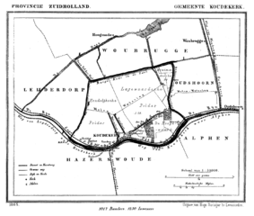
| Description | Historic map of Koudekerk (now part of municipality Rijnwoude), South Holland, the Netherlands |
| Date | between 1865 and 1870 |
| Source | Gemeente Atlas van Nederland (Municipal Atlas of the Netherlands) |
| Author | J. Kuyper |
Licensing
edit
|
This work is in the public domain in its country of origin and other countries and areas where the copyright term is the author's life plus 70 years or fewer.
| |
| This file has been identified as being free of known restrictions under copyright law, including all related and neighboring rights. | |
File history
Click on a date/time to view the file as it appeared at that time.
| Date/Time | Thumbnail | Dimensions | User | Comment | |
|---|---|---|---|---|---|
| current | 17:30, 19 June 2007 | | 1,600 × 1,359 (141 KB) | P199 (talk | contribs) | {{Information |Description=Historic map of Koudekerk (now part of municipality Rijnwoude), South Holland, the Netherlands |Source=Gemeente Atlas van Nederland (Municipal Atlas of the Netherlands) |Date=1865-1870 |Author=J. Kuyper |Permission= |other_versi |
You cannot overwrite this file.
File usage on Commons
There are no pages that use this file.