File:Krajem Chrudimky, CZ171231-019.jpg
Original file (1,795 × 3,208 pixels, file size: 1.88 MB, MIME type: image/jpeg)
Captions
Captions
Summary edit
| Description |
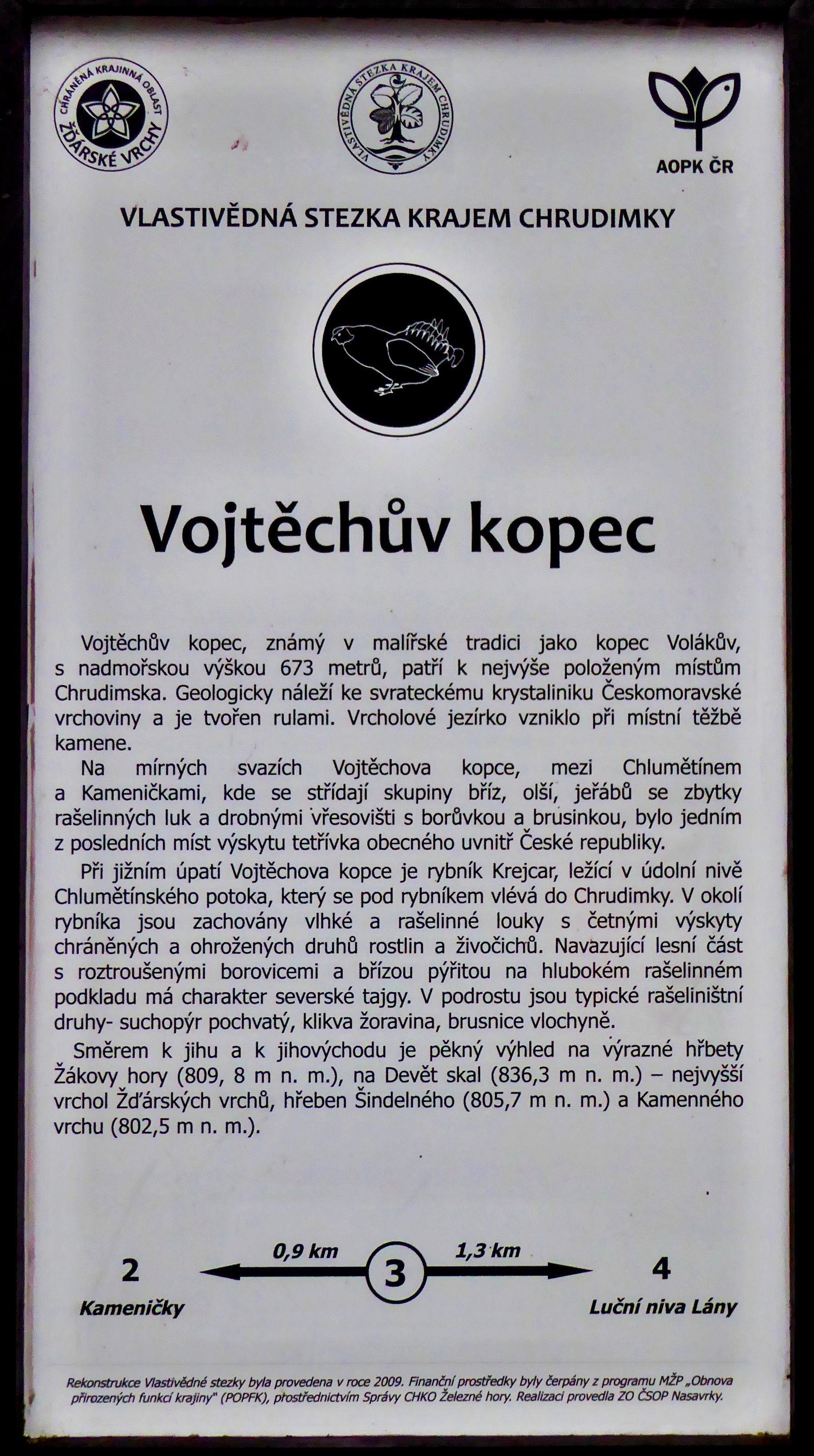
English: Homeland trail of the Region of Chrudimka River, the point "Vojtech's hill", marked with the number 3 on the information board (only czech). "Vojtech's hill" is part of the specially protected territory of the nature reserve with name "Volákův" hill in the Protected Landscape Area "Žďárské" hills. At the homeland trail is point No. 4 with name Meadows with the river in the locality "Lány" away 1.3 km. Photo location: Czechia, Pardubice Region, municipality Kameničky, the nature reserve "Volákův" hill.
Čeština: Vlastivědná stezka Krajem Chrudimky, stanoviště Vojtěchův kopec, označené číslem 3 na informační tabuli. Vojtěchův kopec (673,8 m) je součástí zvláště chráněného území přírodní rezervace Volákův kopec v Chráněné krajinné oblasti Žďárské vrchy. Na vlastivědné stezce je stanoviště 4 s názvem Luční niva Lány vzdálené 1,3 km. Foto lokace: Česko, Pardubický kraj, obec Kameničky, Kameničská vrchovina, přírodní rezervace Volákův kopec (100°). |
| Date | |
| Source | Own work |
| Author | Josef Kreuz (PEPan) |
| Camera location | | View this and other nearby images on: OpenStreetMap |
|---|
Faktografie – doplnění textu na informační tabuli: edit
V textu zmíněný Chlumětínský potok vtéká do rybníku Krejcar od jihovýchodu a odvádí vody v malém průtoku dále k severozápadu do rybníku Groš, který je průtočný řekou Chrudimkou západně od Vojtěchova kopce. Takto je vyznačen průběh Chlumětínského potoku na základní mapě Česka. Od ústí Chlumětínského potoku do rybníku Krejcar je ovšem podél jeho jižního okraje obtokové koryto (na mapě nevyznačené) odvádějící částečně vody z Chlumětínského potoku a také z přelivu rybníku Krejcar do lesní lokality Ohrady, kde přibírá vody i z odtoku v hrázi rybníku a zhruba ve vzdálenosti 500 m je odvádí do Krejcarského potoku. Některé mapy uvádí vodoteč v korytě od hráze rybníku Krejcar k soutoku s Krejcarským potokem jako pokračující Chlumětínský potok. V takovém případě by Chlumětínský potok nebyl levostranným přítokem Chrudimky, ale pravostranným přítokem Krejcarského potoku.
Externí odkazy: edit
- Základní mapa Česka – kompozice přírodní rezervace Volákův kopec viz
- Agentura ochrany přírody a krajiny České republiky – Přírodní rezervace Volákův kopec (kód ÚSOP 1578) viz
- Správa CHKO Žďárské vrchy – PR Volákův kopec, popis lokality viz
- Turistická mapa – Vlastivědná stezka Krajem Chrudimky, Vojtěchův kopec a okolí (letecký pohled) viz
Licensing edit
- You are free:
- to share – to copy, distribute and transmit the work
- to remix – to adapt the work
- Under the following conditions:
- attribution – You must give appropriate credit, provide a link to the license, and indicate if changes were made. You may do so in any reasonable manner, but not in any way that suggests the licensor endorses you or your use.
- share alike – If you remix, transform, or build upon the material, you must distribute your contributions under the same or compatible license as the original.
File history
Click on a date/time to view the file as it appeared at that time.
| Date/Time | Thumbnail | Dimensions | User | Comment | |
|---|---|---|---|---|---|
| current | 12:10, 6 January 2018 | | 1,795 × 3,208 (1.88 MB) | PEPan (talk | contribs) | User created page with UploadWizard |
You cannot overwrite this file.
File usage on Commons
There are no pages that use this file.
File usage on other wikis
The following other wikis use this file:
- Usage on cs.wikipedia.org