File:Krasne (gmina w województwie mazowieckim) location map.png

Size of this preview: 755 × 600 pixels. Other resolutions: 302 × 240 pixels | 605 × 480 pixels | 923 × 733 pixels.
Original file (923 × 733 pixels, file size: 130 KB, MIME type: image/png)
Captions
Captions
Add a one-line explanation of what this file represents
| Description |
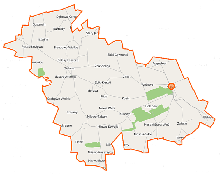
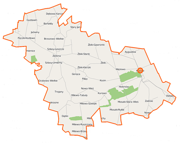
Polski: Mapa gminy Krasne, Polska
English: Map of Gmina Krasne, Poland |
|||||||||
| Date | ||||||||||
| Source | You may find a page on the OpenStreetMap wiki page for Krasne (gmina w województwie mazowieckim) | |||||||||
| Creator |
OpenStreetMap contributors OpenStreetMap contributors |
|||||||||
| Permission (Reusing this file) |
OpenStreetMap data is available under the Open Database License (details). Map tiles are licensed under the Creative Commons Attribution-ShareAlike 2.0 license (CC-BY-SA 2.0).
This file is licensed under the Creative Commons Attribution-Share Alike 2.0 Generic license.
|
|||||||||
| Geotemporal data | ||||||||||
| Bounding box |
|
|||||||||
| Georeferencing | If inappropriate please set warp_status = skip to hide. | |||||||||
File history
Click on a date/time to view the file as it appeared at that time.
| Date/Time | Thumbnail | Dimensions | User | Comment | |
|---|---|---|---|---|---|
| current | 06:55, 23 September 2014 | | 923 × 733 (130 KB) | VanWiel (talk | contribs) | {{OpenStreetMap | name = Krasne (gmina w województwie mazowieckim) | location = Krasne (gmina w województwie mazowieckim) | description = {{pl|Mapa gminy Krasne, Polska}} {{en|Map of Gmina Krasne, Poland}} | top... |
You cannot overwrite this file.
File usage on Commons
There are no pages that use this file.
File usage on other wikis
The following other wikis use this file:
- Usage on fr.wikipedia.org
- Usage on pl.wikipedia.org
- Krasne (gmina w województwie mazowieckim)
- Bartołdy
- Brzozowo Wielkie
- Grabowo Wielkie
- Kraski-Ślesice
- Krasne-Elżbiecin
- Milewo-Brzegędy
- Milewo-Rączki
- Milewo-Szwejki
- Milewo-Tabuły
- Mosaki-Rukle
- Mosaki-Stara Wieś
- Nowe Żmijewo
- Nowokrasne
- Pęczki-Kozłowo
- Szlasy-Umiemy
- Stary Janin
- Żbiki-Gawronki
- Żbiki-Kierzki
- Kozin (województwo mazowieckie)
- Krasne (województwo mazowieckie)
- Milewo-Gawary
- Wężewo (województwo mazowieckie)
- Żbiki (województwo mazowieckie)
- Filipy (powiat przasnyski)
- Kurowo (powiat przasnyski)
- Zalesie (powiat przasnyski)
- Zielona (powiat przasnyski)
- Gustawin
- Gorąca
- Niesiobędy
- Szlasy Żalne
- Augustów (powiat przasnyski)
- Barańce (województwo mazowieckie)
- Brzozowo Małe
- Dąbki (województwo mazowieckie)
- Dębowa Karczma
- Godacze (powiat przasnyski)
- Grabowo Gęsie
- Grabówko (województwo mazowieckie)
- Helenów (powiat przasnyski)
- Iłówko
- Jaźwiny (powiat przasnyski)
- Kamienice-Ślesice
- Kurówko (powiat przasnyski)
- Łyszkowo
- Milewo-Bylice
- Milewo-Kulki
- Milewo-Ruszczyny
View more global usage of this file.
_location_map.png)
_location_map.png&oldid=519971970)