File:Krim 2014 mk.svg

Size of this PNG preview of this SVG file: 665 × 441 pixels. Other resolutions: 320 × 212 pixels | 640 × 424 pixels | 1,024 × 679 pixels | 1,280 × 849 pixels | 2,560 × 1,698 pixels.
Original file (SVG file, nominally 665 × 441 pixels, file size: 232 KB)
Captions
Captions
Add a one-line explanation of what this file represents
Summary edit
| Description |
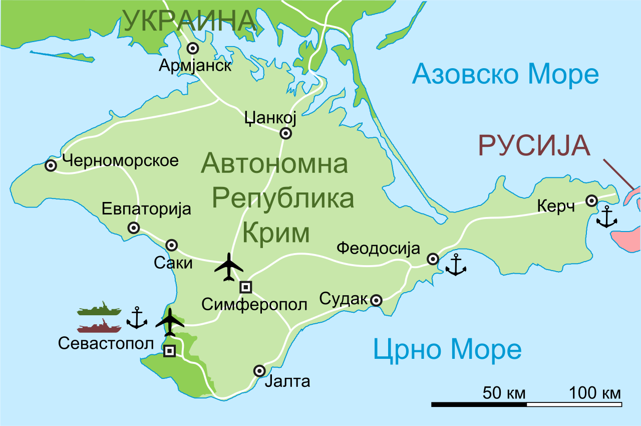
Македонски: Карта на Автономна Република Крим.
English: Map of the Autonomous Republic of Crimea in Macedonian. |
| Date | (UTC) |
| Source |
This file was derived from: Krim 2014 de.svg: |
| Author |
|
| Other versions |
|

| This is a retouched picture, which means that it has been digitally altered from its original version. Modifications: Translated to Macedonian. The original can be viewed here: Krim 2014 de.svg:
|
Licensing edit
I, the copyright holder of this work, hereby publish it under the following license:
| This file is made available under the Creative Commons CC0 1.0 Universal Public Domain Dedication. | |
| The person who associated a work with this deed has dedicated the work to the public domain by waiving all of their rights to the work worldwide under copyright law, including all related and neighboring rights, to the extent allowed by law. You can copy, modify, distribute and perform the work, even for commercial purposes, all without asking permission.
|
Original upload log edit
This image is a derivative work of the following images:
- File:Krim_2014_de.svg licensed with Cc-zero
- 2014-03-05T16:52:25Z Schwarzorange 665x441 (105650 Bytes) moved "Saky" closer to Saky
- 2014-03-04T19:10:26Z Martin Kraft 665x441 (105647 Bytes) Maßstab, +Tschornomorske, diverse kleiner Optimierungen
- 2014-03-04T10:37:29Z Martin Kraft 665x441 (105143 Bytes) Dzhankoi -> Dschankoj
- 2014-03-03T11:25:14Z Martin Kraft 665x441 (105142 Bytes) Straßen, weiter Städte, Farben
- 2014-03-03T08:39:06Z Martin Kraft 665x441 (107470 Bytes) Pfade aufgeräumt. Dateigröße halbiert.
- 2014-03-03T07:42:55Z Furfur 665x441 (234096 Bytes) Sinferopol -> Simferopol
- 2014-03-02T22:39:24Z Martin Kraft 665x441 (230200 Bytes) +Flughafen
- 2014-03-02T22:27:31Z Martin Kraft 665x441 (231225 Bytes) Ohne Schraffur ist doch irgendwie besser
- 2014-03-02T22:14:14Z Martin Kraft 665x441 (235068 Bytes) Karte komplett überarbeitet. Bei Nichtgefallen einfach revertieren, dann stelle ich sie seperat ein
- 2014-03-02T20:44:01Z Furfur 665x441 (320405 Bytes) verbessert
- 2014-03-02T20:07:50Z Furfur 665x441 (307976 Bytes) Golf von Asow -> Asowsches Meer
- 2014-03-02T18:32:08Z Furfur 665x441 (304260 Bytes) ... something went wrong with the graphic display, try to correct it ...
- 2014-03-02T18:28:24Z Furfur 665x441 (249928 Bytes) == {{int:filedesc}} == {{Information |Description={{de|Karte der Krim-Republik.}} {{en|Map of the Autonomous Republic of Crimea and of Sevastopol, Ukraine.}} |Source={{Derived from|Crimea_republic_map.png|display=50}} |Date=2
Uploaded with derivativeFX
File history
Click on a date/time to view the file as it appeared at that time.
| Date/Time | Thumbnail | Dimensions | User | Comment | |
|---|---|---|---|---|---|
| current | 19:21, 6 March 2014 | | 665 × 441 (232 KB) | Bjankuloski06 (talk | contribs) | {{Information |Description ={{en|1=s}} {{mk|1=s}} |Source =d |Author =s |Date = |Permission = |other_versions = }} |
You cannot overwrite this file.
File usage on Commons
The following 2 pages use this file: