File:Kroatien Autobahnen (aktueller Stand).svg

Size of this PNG preview of this SVG file: 749 × 600 pixels. Other resolutions: 300 × 240 pixels | 599 × 480 pixels | 959 × 768 pixels | 1,279 × 1,024 pixels | 2,557 × 2,048 pixels | 1,402 × 1,123 pixels.
Original file (SVG file, nominally 1,402 × 1,123 pixels, file size: 1.12 MB)
Captions
Captions
Add a one-line explanation of what this file represents
| Description |
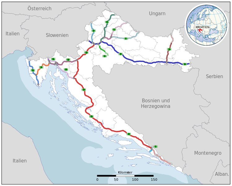
Deutsch: Autobahnnetz Kroatien, Ausbaustand Dezember 2009
durchgezogene Linien = fertiggestellte Autobahnen, für den Verkehr freigegeben
gepunktete Linien = geplante oder in Bau befindliche Autobahnabschnitte English: Highway network in Croatia, December 2009
unbroken lines = completed highways, in use broken lines = highways planned or under construction |
| Date | (UTC) |
| Source | |
| Author |
|
| Other versions |
|
_hr.svg)
.svg)
I, the copyright holder of this work, hereby publish it under the following license:
This file is licensed under the Creative Commons Attribution-Share Alike 3.0 Unported license.
- You are free:
- to share – to copy, distribute and transmit the work
- to remix – to adapt the work
- Under the following conditions:
- attribution – You must give appropriate credit, provide a link to the license, and indicate if changes were made. You may do so in any reasonable manner, but not in any way that suggests the licensor endorses you or your use.
- share alike – If you remix, transform, or build upon the material, you must distribute your contributions under the same or compatible license as the original.
Original upload log edit
.svg&action=edit§ion=1)
This image is a derivative work of the following images:
- File:Kroatien_Autobahnen_(Karte).svg licensed with Cc-by-sa-3.0
- 2009-12-26T16:34:04Z Minestrone 1402x1123 (1182323 Bytes) Farbänderungen, dickere Pfade
- 2009-06-19T20:36:28Z Jeremiah21 1402x1123 (1186179 Bytes) korr
- 2009-06-19T20:20:23Z Jeremiah21 701x562 (1189444 Bytes) korr
- 2009-06-19T19:47:40Z Jeremiah21 701x562 (1201374 Bytes) {{Information |Description=Autobahnnetz Kroatien |Source=own work , usingSigns from von [[User:Mmichaal|Mmichaal]]Map from [[User:Chumwa|Chumwa]] |Date=2009-06-19 |Author=[[User:Jeremiah21|Jeremiah21]] |Permission= |other_ver
Uploaded with derivativeFX
File history
Click on a date/time to view the file as it appeared at that time.
.svg&dir=prev)
.svg&offset=20091226224530)
.svg&offset=&limit=20)
.svg&offset=&limit=50)
.svg&offset=&limit=100)
.svg&offset=&limit=250)
.svg&offset=&limit=500)
| Date/Time | Thumbnail | Dimensions | User | Comment | |
|---|---|---|---|---|---|
| current | 15:50, 25 December 2023 | | 1,402 × 1,123 (1.12 MB) | MaGa (talk | contribs) | Reverted to version as of 19:19, 5 June 2015 (UTC) (it has to be updated File:Kroatien Autobahnen (aktueller Stand) hr.svg |
| 15:49, 25 December 2023 |  | 1,381 × 1,104 (874 KB) | MaGa (talk | contribs) | A5 update | |
| 19:19, 5 June 2015 |  | 1,402 × 1,123 (1.12 MB) | Nicthurne (talk | contribs) | A11 bis Lekenik, A1 bis Ploče | |
| 17:31, 5 January 2010 |  | 1,402 × 1,123 (1.11 MB) | Minestrone (talk | contribs) | Farbänderungen, klarere Hervorhebung | |
| 01:11, 29 December 2009 |  | 1,402 × 1,123 (1.11 MB) | Minestrone (talk | contribs) | Änderungen A7 | |
| 17:34, 27 December 2009 |  | 1,402 × 1,123 (1.11 MB) | Minestrone (talk | contribs) | vergaß Grenzübergang an A10 | |
| 17:14, 27 December 2009 |  | 1,402 × 1,123 (1.11 MB) | Minestrone (talk | contribs) | Grenzübergänge | |
| 15:01, 27 December 2009 |  | 1,402 × 1,123 (1.07 MB) | Minestrone (talk | contribs) | changes A1 near Dubrovnik | |
| 00:34, 27 December 2009 |  | 1,402 × 1,123 (1.07 MB) | Minestrone (talk | contribs) | A12 and A13 update | |
| 22:45, 26 December 2009 |  | 1,402 × 1,123 (1.07 MB) | Minestrone (talk | contribs) | minor edits (Rijeka area) |
You cannot overwrite this file.
File usage on Commons
The following 4 pages use this file:
File usage on other wikis
The following other wikis use this file:
- Usage on de.wikipedia.org
- Usage on en.wikipedia.org
- Usage on hr.wikipedia.org
- Usage on lt.wikipedia.org
- Usage on nl.wikipedia.org
- Usage on pl.wikipedia.org
- Usage on rm.wikipedia.org
- Usage on sk.wikipedia.org
- Usage on tr.wikipedia.org
- Usage on zh.wikipedia.org
.svg&oldid=834907329)