File:KummeVorschläge.jpg
Size of this preview: 800 × 269 pixels. Other resolutions: 320 × 108 pixels | 640 × 215 pixels | 1,638 × 551 pixels.
Original file (1,638 × 551 pixels, file size: 1.02 MB, MIME type: image/jpeg)
Captions
Captions
Add a one-line explanation of what this file represents
Summary edit
| Description |
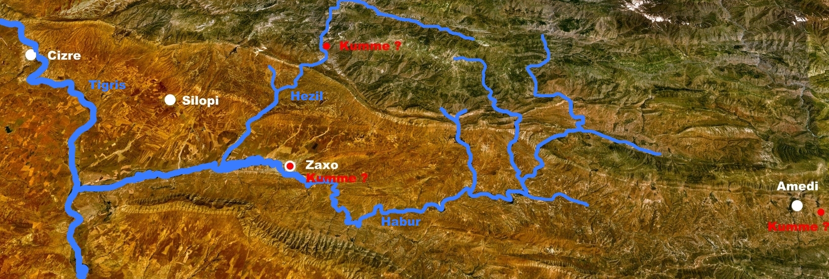
Deutsch: Landsat7 Aufnahme mit Lokalisierungsvorschlägen Kummes (Zaxo, Komane (=Kwani), oberer Hesil suyu)
Quelle geprüft. |
| Date | abgerufen 04.02.2009 |
| Source | NASA World Wind; NLT Landsat7 Aufnahme des irakisch-türkisch-syrischen Drei-Länder-Ecks |
| Author | NASA; von Mursilis eingefügte Ortsnamen und Punkte |
Licensing edit
| This file is in the public domain in the United States because it was solely created by NASA. NASA copyright policy states that "NASA material is not protected by copyright unless noted". (See Template:PD-USGov, NASA copyright policy page or JPL Image Use Policy.) | ||
 |
Warnings:
|
Original upload log edit
Transferred from de.wikipedia to Commons by Nachcommonsverschieber.
The original description page was here. All following user names refer to de.wikipedia.
- 2009-02-05 08:40 Mursilis 1638×551× (1068362 bytes) {{Information |Beschreibung = World Wind Landsat7 Aufnahme mit Lokalisierungsvorschlägen Kummes (Zaxo, Komane (=Kwani), oberer Hesil suyu) |Quelle = [[NASA World Wind]]; NLT Landsat7 Aufnahme des irakisch-türkisch-syrischen Drei-Länder-Ecks |Urheber =
- 2009-02-05 00:18 Mursilis 1638×551× (1114514 bytes) {{Information |Beschreibung = Landsat7 Aufnahme mit Lokalisierungsvorschlägen Kummes (Zaxo, Komane (=Kwani), oberer Hesil suyu) |Quelle = NASA World Wind; NLT Landsat7 |Urheber = NASA; selbst eingefügte Ortsnamen und Punkte |Datum = abgerufen 04.02.2009
File history
Click on a date/time to view the file as it appeared at that time.
| Date/Time | Thumbnail | Dimensions | User | Comment | |
|---|---|---|---|---|---|
| current | 10:04, 23 February 2013 | 1,638 × 551 (1.02 MB) | Nachcommonsverschieber (talk | contribs) | second, latest version | |
| 10:01, 23 February 2013 | 1,638 × 551 (1.06 MB) | Nachcommonsverschieber (talk | contribs) | {{Information |Description={{de|Landsat7 Aufnahme mit Lokalisierungsvorschlägen Kummes (Zaxo, Komane (=Kwani), oberer Hesil suyu)}} |Source=Transferred from [http://de.wikipedia.org de.wikipedia]; transfer was stated to be made by [[User:Nachcommonsve... |
You cannot overwrite this file.
File usage on Commons
There are no pages that use this file.
File usage on other wikis
The following other wikis use this file:
- Usage on de.wikipedia.org
- Usage on www.wikidata.org