File:Kuryłówka (gmina) location map.png

Original file (2,198 × 1,789 pixels, file size: 539 KB, MIME type: image/png)
Captions
Captions
Summary
edit_location_map.png&action=edit§ion=1)
| Description |
English: Location map |
| Date | |
| Source | Own work |
| Author | Smat |
| Description |
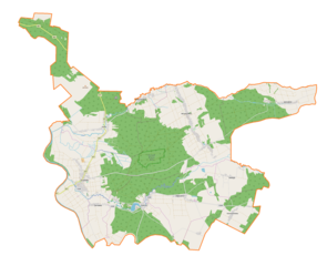
Polski: Mapa gminy Kuryłówka, Polska
English: Map of Kuryłówka (gmina), Poland |
|||||||||
| Date | ||||||||||
| Source | You may find a page on the OpenStreetMap wiki page for Kuryłówka (gmina) | |||||||||
| Creator |
OpenStreetMap contributors OpenStreetMap contributors |
|||||||||
| Permission (Reusing this file) |
OpenStreetMap data is available under the Open Database License (details). Map tiles are licensed under the Creative Commons Attribution-ShareAlike 2.0 license (CC-BY-SA 2.0).
This file is licensed under the Creative Commons Attribution-Share Alike 2.0 Generic license.
|
|||||||||
| Geotemporal data | ||||||||||
| Bounding box |
|
|||||||||
| Georeferencing | If inappropriate please set warp_status = skip to hide. | |||||||||
Licensing
edit_location_map.png&action=edit§ion=2)
| This work contains information from OpenStreetMap, which is made available under the Open Database License (ODbL).
The ODbL does not require any particular license for maps produced from ODbL data. Prior to 1 August 2020, map tiles produced by the OpenStreetMap Foundation were licensed under the CC-BY-SA-2.0 license. Maps produced by other people may be subject to other licences. |
File history
Click on a date/time to view the file as it appeared at that time.
| Date/Time | Thumbnail | Dimensions | User | Comment | |
|---|---|---|---|---|---|
| current | 15:42, 20 July 2018 | | 2,198 × 1,789 (539 KB) | Smat (talk | contribs) | User created page with UploadWizard |
You cannot overwrite this file.
File usage on Commons
The following page uses this file:
File usage on other wikis
The following other wikis use this file:
- Usage on be.wikipedia.org
- Usage on pl.wikipedia.org
- Rezerwat przyrody Brzyska Wola
- Brzyska Wola
- Kulno
- Kuryłówka
- Kolonia Polska
- Tarnawiec
- Wólka Łamana
- Ożanna (wieś)
- Jastrzębiec (województwo podkarpackie)
- Słoboda (województwo podkarpackie)
- Dąbrowica (powiat leżajski)
- Cerkiew św. Michała Archanioła w Kulnie
- Parafia św. Józefa w Tarnawcu
- Parafia Matki Bożej Pocieszenia w Brzyskiej Woli
- Parafia św. Stanisława Biskupa w Kolonii Polskiej
- Most w Kuryłówce
- Kościół św. Józefa w Kuryłówce
- Zamek w Kuryłówce
- Cerkiew św. Paraskewy w Kuryłówce
- Cmentarz w Kulnie
- Pomnik na Pamiątkę Wskrzeszenia Ojczyzny w Kuryłówce
- Cerkiew św. Paraskewy w Dąbrowicy
- Kościół Najświętszego Serca Pana Jezusa w Jastrzębcu
- Kościół św. Antoniego w Ożannie
- Kościół św. Stanisława w Kolonii Polskiej
- Kościół Matki Bożej Pocieszenia w Brzyskiej Woli
- Pomnik poległych żołnierzy AK w Kuryłówce
- Moduł:Mapa/dane/Kuryłówka (gmina)
- Cztery Chałupy
- Polski Koniec
- Czarnuchy (Wólka Łamana)
- Usage on pl.wikibooks.org
- Usage on ru.wikipedia.org
- Usage on www.wikidata.org
_location_map.png&oldid=704806549)