File:Kyrgyzstan 40to44N 69to82E Topo Rainbow Zebra 2040.jpg

Size of this preview: 800 × 246 pixels. Other resolutions: 320 × 98 pixels | 640 × 197 pixels | 1,024 × 315 pixels | 1,280 × 394 pixels | 2,560 × 788 pixels | 15,600 × 4,800 pixels.
Original file (15,600 × 4,800 pixels, file size: 57.04 MB, MIME type: image/jpeg)
Captions
Captions
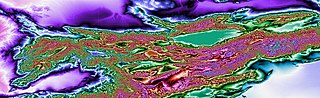
Topographic map of Kyrgyzstan.
Summary
edit
| Description |
English: This topographic map shows most of Kyrgyzstan. The map's coverage extends from 40 to 44 degrees north latitude and from 69 to 82 degrees east longitude. Produced with Map Render 3D from GHz Limited. Then used IrfanView to stitch together multiple maps. |
| Date | |
| Source | [3 arc second Digital Elevation Models obtained from the website http://www.viewfinderpanoramas.org/dem3.html] |
| Author | Jonathan de Ferranti |
Licensing
edit
| This file is in the public domain in the United States because it was solely created by NASA. NASA copyright policy states that "NASA material is not protected by copyright unless noted". (See Template:PD-USGov, NASA copyright policy page or JPL Image Use Policy.) | ||
 |
Warnings:
|
File history
Click on a date/time to view the file as it appeared at that time.
| Date/Time | Thumbnail | Dimensions | User | Comment | |
|---|---|---|---|---|---|
| current | 22:41, 28 February 2020 | 15,600 × 4,800 (57.04 MB) | Rainbow Zebra 13 (talk | contribs) | Improved the stitching together of the map tiles by using IrfanView instead of Image Composite Editor. | |
| 05:01, 23 May 2017 | 15,457 × 4,765 (57.93 MB) | Rainbow Zebra 13 (talk | contribs) | User created page with UploadWizard |
You cannot overwrite this file.
File usage on Commons
The following page uses this file: