File:LASB K Hellwig 1057.jpg

Size of this preview: 800 × 503 pixels. Other resolutions: 320 × 201 pixels | 640 × 403 pixels | 1,024 × 644 pixels | 1,280 × 805 pixels | 2,560 × 1,611 pixels | 4,980 × 3,133 pixels.
Original file (4,980 × 3,133 pixels, file size: 2.87 MB, MIME type: image/jpeg)
Captions
Captions
Add a one-line explanation of what this file represents
Summary edit
| Description |
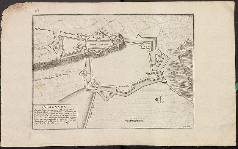
Deutsch: Plan der Zitadelle und weiteren Befestigungsanlagen von Homburg (HOMBOURG Est vne Forteresse considerable du Comté de Sarbrick Située entre les Villes de Sarbrick et de Caseloutre,prés celle de Deux-Ponts 49. de=grez 25. minutes de latitude et 29. degrez de lon=gitude, Son Chateau est construit sur vne Ville, l'un et l'autre fortifiés par les François par qui cette Place est possedée depuis l'an 1679 .) - Kupferstich - französisch - in Eschelle - 25 x 41 cm - [ca. 1700] |
| Date | |
| Source | Landesarchiv Saarbrücken, Kartensammlung Hellwig Nr. 1057 |
| Author | de Fer, Nicolas (1646 - 1720) |
Licensing edit
| Media uploaded by user LandesarchivSaarbrücken are released under CC-BY-SA 3.0 DE. |
This file is licensed under the Creative Commons Attribution-Share Alike 3.0 Germany license. Attribution: Landesarchiv Saarbrücken, Bestand K Hellwig, Nr. 1057, Urheber Nicolas de Fer (1646-1720) / CC-BY-SA 3.0 DE
 |
File history
Click on a date/time to view the file as it appeared at that time.
| Date/Time | Thumbnail | Dimensions | User | Comment | |
|---|---|---|---|---|---|
| current | 05:35, 4 June 2021 | | 4,980 × 3,133 (2.87 MB) | LandesarchivSaarbrücken (talk | contribs) | Uploaded a work by de Fer, Nicolas (1646 - 1720) from Landesarchiv Saarbrücken, Kartensammlung Hellwig Nr. 1057 with UploadWizard |
You cannot overwrite this file.
File usage on Commons
The following page uses this file:
File usage on other wikis
The following other wikis use this file:
- Usage on de.wikipedia.org
- Usage on en.wikipedia.org
- Usage on fr.wikipedia.org