File:LA Earthquake July 29 2008.jpg
Size of this preview: 511 × 600 pixels. Other resolutions: 204 × 240 pixels | 612 × 718 pixels.
Original file (612 × 718 pixels, file size: 116 KB, MIME type: image/jpeg)
Captions
Captions
Add a one-line explanation of what this file represents
| Description |
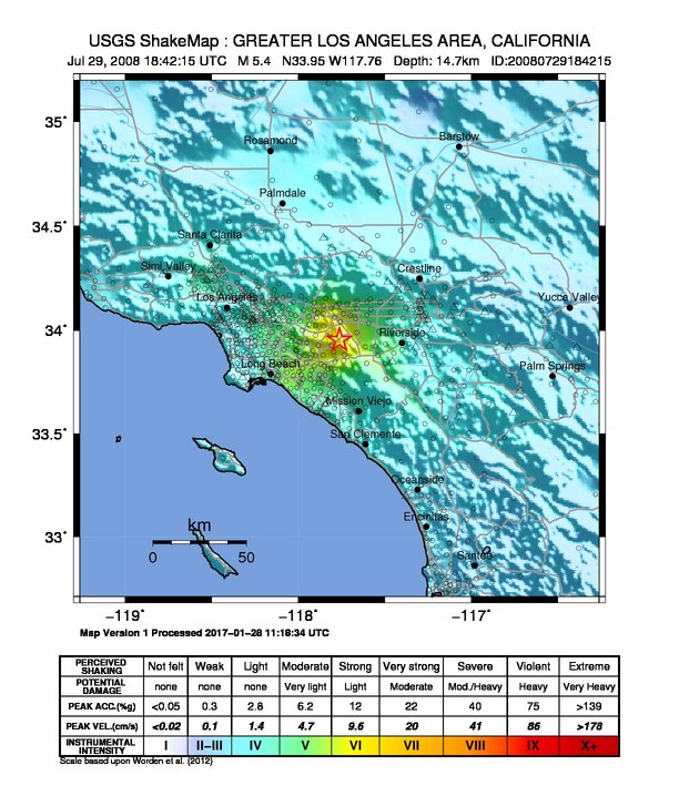
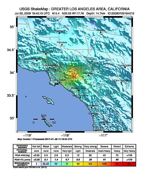
English: The 2008 Chino Hills earthquake.
|
|||
| Date | ||||
| Source | USGS | |||
| Author | United States Geological Survey | |||
| Permission (Reusing this file) |
|
File history
Click on a date/time to view the file as it appeared at that time.
| Date/Time | Thumbnail | Dimensions | User | Comment | |
|---|---|---|---|---|---|
| current | 05:12, 2 February 2020 | | 612 × 718 (116 KB) | Tinh1000000 (talk | contribs) | ATLAS 2017-04-12 revision |
| 19:14, 29 July 2008 |  | 612 × 626 (195 KB) | DragonFire1024 (talk | contribs) | {{Information |Description={{en|1=Shake map showing damage possibility following a magnitude 5.8 earthquake in Chino Hills California on July 29, 2008.}} |Source=http://earthquake.usgs.gov/eqcenter/shakemap/sc/shake/14383980/ |Author=United States Geologi |
You cannot overwrite this file.
File usage on Commons
The following page uses this file:
File usage on other wikis
The following other wikis use this file:
- Usage on bn.wikipedia.org
- Usage on en.wikipedia.org
- Usage on en.wikinews.org
- Usage on es.wikipedia.org
- Usage on it.wikinews.org
- Usage on pt.wikinews.org
- Usage on www.wikidata.org
- Usage on zh.wikinews.org