File:LB and SCRly map 204.jpg
Original file (1,500 × 1,972 pixels, file size: 1.6 MB, MIME type: image/jpeg)
Captions
Captions
Summary edit

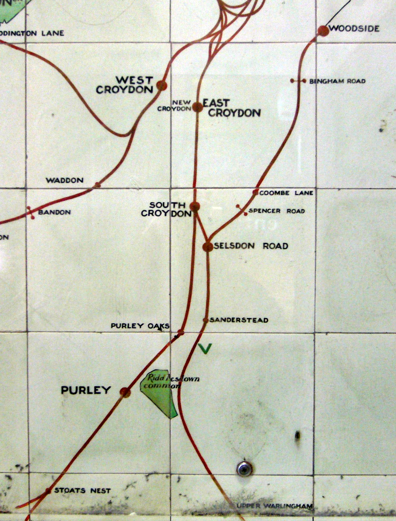
Part of a map of the suburban lines of the London, Brighton and South Coast Railway made in ceramic tiles and on display at Victoria Station. It dates from after 1905 (because Bandon Halt station opened in 1906) and from before 1911 (because it shows Stoats Nest station which was renamed in that year).
At the centre of the image on the right is a station entrance. Go in there and look to your left. You will see a ceramic map of the whole of the LB&SCR network. A few steps further on and also on the left is this map. (Some of you have walked past it many times and never seen it!)
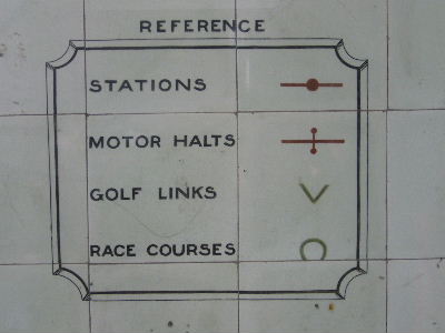
The map key describes Bingham Road, Spencer Road and Bandon as "motor halts". The green 'V' below Sanderstead marks a golf club, presumably Purley Downs GC.
The silver object near the bottom is the head of a screw which is holding a protective perspex sheet in place.
.jpg)
Licensing edit
|
This is a faithful photographic reproduction of a two-dimensional, public domain work of art. The work of art itself is in the public domain for the following reason:
The official position taken by the Wikimedia Foundation is that "faithful reproductions of two-dimensional public domain works of art are public domain". This photographic reproduction is therefore also considered to be in the public domain in the United States. In other jurisdictions, re-use of this content may be restricted; see Reuse of PD-Art photographs for details. {{PD-Art}} template without license parameter: please specify why the underlying work is public domain in both the source country and the United States
(Usage: {{PD-Art|1=|deathyear=''year of author's death''|country=''source country''}}, where parameter #1 can be PD-old-auto, PD-old-auto-expired, PD-old-auto-1996, PD-old-100 or similar. See Commons:Multi-license copyright tags for more information.) | ||||
but for the ruling cited above, I would licence this as my own work with Roger W Haworth's licence.
File history
Click on a date/time to view the file as it appeared at that time.
| Date/Time | Thumbnail | Dimensions | User | Comment | |
|---|---|---|---|---|---|
| current | 09:17, 15 May 2018 | | 1,500 × 1,972 (1.6 MB) | Belbury (talk | contribs) | increase contrast |
| 17:27, 28 March 2007 |  | 1,500 × 1,972 (327 KB) | RHaworth (talk | contribs) | ||
| 17:14, 28 March 2007 |  | 1,536 × 2,048 (374 KB) | RHaworth (talk | contribs) |
You cannot overwrite this file.
File usage on Commons
The following 7 pages use this file:
- London Borough of Croydon
- User:Chumwa/OgreBot/Potential transport maps/2018 May 11-20
- User:Chumwa/OgreBot/Public transport information/2018 May 11-20
- User:Chumwa/OgreBot/Transport Maps/2018 May 11-20
- User:Chumwa/OgreBot/Travel and communication maps/2018 May 11-20
- User:Mattbuck/Railways/2018 May 11-20
- File:LB and SCRly map 204 (cropped).jpg
File usage on other wikis
The following other wikis use this file:
- Usage on en.wikipedia.org
- Usage on he.wikipedia.org
- Usage on www.wikidata.org