File:LGA Airport Diagram.svg

Size of this PNG preview of this SVG file: 378 × 552 pixels. Other resolutions: 164 × 240 pixels | 329 × 480 pixels | 526 × 768 pixels | 701 × 1,024 pixels | 1,402 × 2,048 pixels.
Original file (SVG file, nominally 378 × 552 pixels, file size: 781 KB)
Captions
Captions
Add a one-line explanation of what this file represents
Summary
edit
| Description |
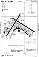
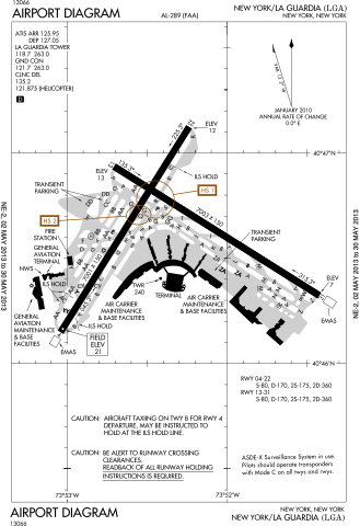
English: FAA Airport Diagram of LaGuardia Airport |
| Date | |
| Source |
FAA Airport Diagrams; note that these change every 28 days. Taken from PDF on FAA site and converted to SVG using en:Wikipedia:How to draw SVG circuits using Xcircuit. |
| Author | Produced by the National Aeronautical Charting Office (NACO), a department of the United States en:Federal Aviation Administration. |
| Camera location | | View this and other nearby images on: OpenStreetMap |
|---|
W3C-validity not checked.
Licensing
edit
This image or file is a work of a Federal Aviation Administration employee, taken or made as part of that person's official duties. As a work of the U.S. federal government, the image is in the public domain in the United States.
|
 |
File history
Click on a date/time to view the file as it appeared at that time.
| Date/Time | Thumbnail | Dimensions | User | Comment | |
|---|---|---|---|---|---|
| current | 03:29, 2 May 2013 | | 378 × 552 (781 KB) | Grendelkhan (talk | contribs) | SVG version of FAA's PDF diagram. |
You cannot overwrite this file.
File usage on Commons
The following 3 pages use this file:
File usage on other wikis
The following other wikis use this file:
- Usage on mr.wikipedia.org
- Usage on new.wikipedia.org
- Usage on ta.wikipedia.org