File:LGA airport map.svg

Size of this PNG preview of this SVG file: 390 × 599 pixels. Other resolutions: 156 × 240 pixels | 313 × 480 pixels | 500 × 768 pixels | 667 × 1,024 pixels | 1,334 × 2,048 pixels | 484 × 743 pixels.
Original file (SVG file, nominally 484 × 743 pixels, file size: 587 KB)
Captions
Captions
Add a one-line explanation of what this file represents

|
This file has been superseded by LGA Airport Diagram.svg. It is recommended to use the other file. Please note that deleting superseded images requires consent.
|

|
Summary edit
| Description |
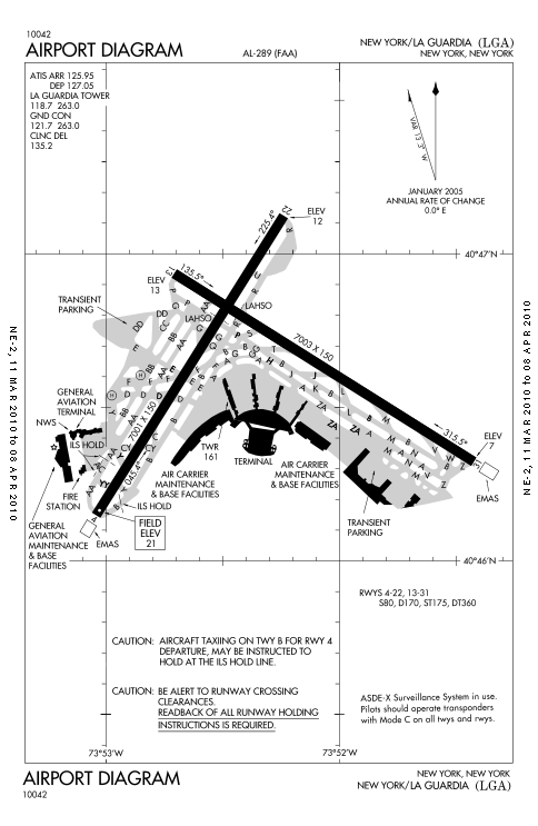
English: FAA diagram of LaGuardia Airport. |
| Date | |
| Source | http://204.108.4.16/d-tpp/1003/00289AD.PDF |
| Author | FAA |
| Other versions | Derivative works of this file: USAir4051992f28crashlocation.jpg |
Licensing edit
This work is in the public domain in the United States because it is a work prepared by an officer or employee of the United States Government as part of that person’s official duties under the terms of Title 17, Chapter 1, Section 105 of the US Code.
Note: This only applies to original works of the Federal Government and not to the work of any individual U.S. state, territory, commonwealth, county, municipality, or any other subdivision. This template also does not apply to postage stamp designs published by the United States Postal Service since 1978. (See § 313.6(C)(1) of Compendium of U.S. Copyright Office Practices). It also does not apply to certain US coins; see The US Mint Terms of Use.
|
 | |
| This file has been identified as being free of known restrictions under copyright law, including all related and neighboring rights. | ||
File history
Click on a date/time to view the file as it appeared at that time.
| Date/Time | Thumbnail | Dimensions | User | Comment | |
|---|---|---|---|---|---|
| current | 04:16, 15 March 2010 | | 484 × 743 (587 KB) | Atmoz (talk | contribs) | {{Information |Description={{en|1=FAA diagram of LaGuardia Airport.}} |Source=http://204.108.4.16/d-tpp/1003/00289AD.PDF |Author=FAA |Date=11 MAR 2010 |Permission= |other_versions= }} Category:LaGuardia Airport |
You cannot overwrite this file.
File usage on Commons
The following page uses this file:
File usage on other wikis
The following other wikis use this file:
- Usage on ban.wikipedia.org
- Usage on cs.wikipedia.org
- Usage on en.wikipedia.org
- Usage on fa.wikipedia.org
- Usage on fr.wikipedia.org
- Usage on he.wikipedia.org
- Usage on hu.wikipedia.org
- Usage on id.wikipedia.org
- Usage on it.wikipedia.org
- Usage on sq.wikipedia.org
- Usage on th.wikipedia.org
- Usage on vi.wikipedia.org