File:LINE21.jpg
Size of this preview: 800 × 552 pixels. Other resolutions: 320 × 221 pixels | 640 × 442 pixels | 1,000 × 690 pixels.
Original file (1,000 × 690 pixels, file size: 102 KB, MIME type: image/jpeg)
Captions
Captions
Add a one-line explanation of what this file represents
Summary
edit
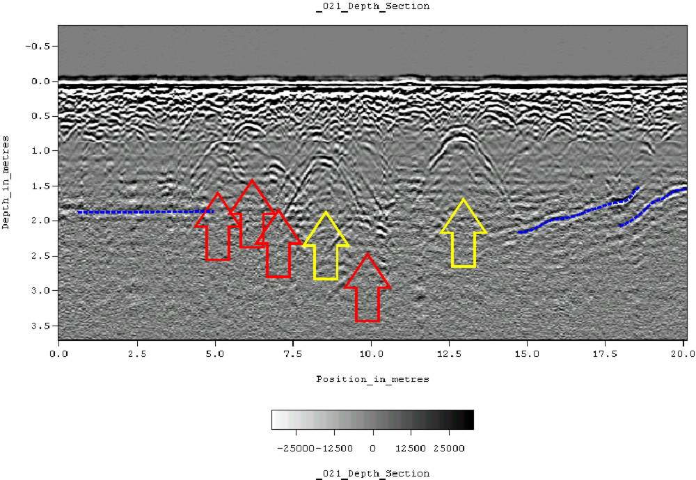
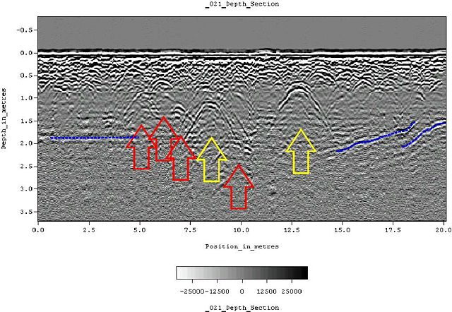
| Description | Ground-penetrating radar depth section (profile) collected on an historic cemetery in Alabama, USA. Yellow arrows indicate very distinct reflections, probably associated with human burials. "hyperbolic" reflections, appearing as an inverted U, are typically associated with discrete objects. Less distinct hyperbolic reflections are indicated by red arrows. dashed blue lines indicate horizontal and sloping reflectors, probably bedrock. The many smaller reflections near the surface are likely to be caused by tree roots. Because of the nature of the site, subsurface testing was not conducted, but these interpretations are supported by surface indications (grave markers and depressions) and with line-to-line patterning within the GPR data. |
| Date | 11 June 2007 (original upload date) |
| Source | Transferred from en.wikipedia to Commons. |
| Author | Tapatio at English Wikipedia |
Licensing
edit
| This work has been released into the public domain by its author, Tapatio at English Wikipedia. This applies worldwide. In some countries this may not be legally possible; if so: Tapatio grants anyone the right to use this work for any purpose, without any conditions, unless such conditions are required by law. |
Original upload log
edit
The original description page was here. All following user names refer to en.wikipedia.
- 2007-06-11 05:16 Tapatio 1000×690×8 (104839 bytes) {{PD-self}}
- 2007-06-11 04:49 Tapatio 1000×690×8 (104839 bytes) Ground-penetrating radar depth section (profile) collected on an historic cemetery in Alabama, USA. Yellow arrows indicate very distinct reflections, probably associated with human burials. "Parabolic" reflections, appearing as an inverted U, are typicall
File history
Click on a date/time to view the file as it appeared at that time.
| Date/Time | Thumbnail | Dimensions | User | Comment | |
|---|---|---|---|---|---|
| current | 19:02, 17 October 2007 | | 1,000 × 690 (102 KB) | Conscious (talk | contribs) | full resolution |
| 19:22, 2 October 2007 |  | 800 × 552 (105 KB) | Rosarinagazo (talk | contribs) | Ground-penetrating radar depth section (profile) collected on an historic cemetery in Alabama, USA. Yellow arrows indicate very distinct reflections, probably associated with human burials. "hyperbolic" reflections, appearing as an inverted U, are typical |
You cannot overwrite this file.
File usage on Commons
There are no pages that use this file.
File usage on other wikis
The following other wikis use this file:
- Usage on ar.wikipedia.org
- Usage on ca.wikipedia.org
- Usage on da.wikipedia.org
- Usage on de.wikipedia.org
- Usage on el.wikipedia.org
- Usage on en.wikipedia.org
- Usage on es.wikipedia.org
- Usage on et.wikipedia.org
- Usage on fr.wikipedia.org
- Usage on he.wikipedia.org
- Usage on ml.wikipedia.org
- Usage on nl.wikipedia.org
- Usage on nn.wikipedia.org
- Usage on no.wikipedia.org
- Usage on pl.wikipedia.org
- Usage on pt.wikipedia.org
- Usage on sk.wikipedia.org
- Usage on vi.wikipedia.org
- Usage on zh.wikipedia.org