File:La Couture (62) - Centre - 1.JPG

Original file (2,448 × 3,264 pixels, file size: 1.47 MB, MIME type: image/jpeg)
Captions
Captions
Summary
edit_-_Centre_-_1.JPG&action=edit§ion=1)
| Description |
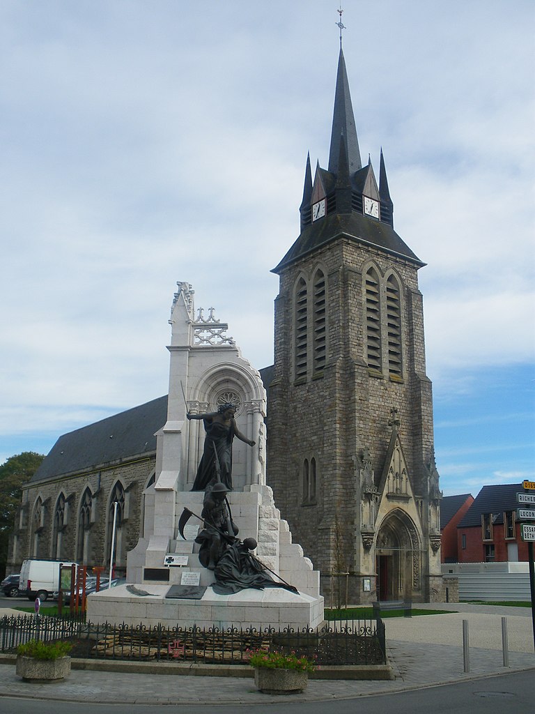
Français : Monument en hommage aux combattants portugais de la Première guerre mondiale, situé à La Couture, plus l'église.
Português: Portugal deixou também um monumento aos mortos da Grande Guerra em França, que ofereceu ao município de La Couture, um dos locais onde decorreu a batalha nas margens do rio La Lys, em 1918.
Inaugurado em 1928, o monumento é quase mais alto do que o edifício da igreja, em tijoleira vermelha, típico desta região da Flandres francesa. Mas nada neste monumento é típico: se os soldados dos monumentos franceses costumam ter um ar impassível ou vitorioso, glorificando a morte ou saudando a vitória, o português aqui representado tem uma máscara de puro terror no rosto. O seu inimigo é a própria morte, que enfrenta à força de coronhadas e não de balas. Atrás de si, uma figura feminina, que representa Portugal, empunha a espada de Nun’Álvares Pereira, para o ajudar no combate desigual. A seus pés, muitos destroços. O que espanta é que tudo indica que se trata de um monumento à derrota, e não a uma vitória – o esqueleto da morte, com a gadanha, parece pronto a ceifar o soldado, mesmo com a ajuda da espada do Condestável que noutros tempos combateu os castelhanos. |
| Date | |
| Source | Own work |
| Author | Floflo62 |
Licensing
edit_-_Centre_-_1.JPG&action=edit§ion=2)
- You are free:
- to share – to copy, distribute and transmit the work
- to remix – to adapt the work
- Under the following conditions:
- attribution – You must give appropriate credit, provide a link to the license, and indicate if changes were made. You may do so in any reasonable manner, but not in any way that suggests the licensor endorses you or your use.
- share alike – If you remix, transform, or build upon the material, you must distribute your contributions under the same or compatible license as the original.
| Camera location | | View this and other nearby images on: OpenStreetMap |
|---|
_-_Centre_-_1.JPG¶ms=050.581180_N_0002.715245_E_globe:Earth_type:camera_alt:65.9_source:exif_&language=en)
File history
Click on a date/time to view the file as it appeared at that time.
| Date/Time | Thumbnail | Dimensions | User | Comment | |
|---|---|---|---|---|---|
| current | 09:27, 1 November 2013 | | 2,448 × 3,264 (1.47 MB) | Floflo62 (talk | contribs) | User created page with UploadWizard |
You cannot overwrite this file.
File usage on Commons
There are no pages that use this file.
File usage on other wikis
The following other wikis use this file:
- Usage on br.wikipedia.org
- Usage on fr.wikipedia.org
- Usage on pcd.wikipedia.org
- Usage on pt.wikipedia.org
- Usage on vls.wikipedia.org
_-_Centre_-_1.JPG&oldid=600105077)