File:La Défense des Côtes du Cotentin Le Passage de la Déroute Le Canal de la Déroute ERNOUF Guillaume.jpg

Size of this preview: 800 × 581 pixels. Other resolutions: 320 × 233 pixels | 640 × 465 pixels | 1,024 × 744 pixels | 1,280 × 930 pixels | 2,560 × 1,860 pixels | 4,211 × 3,060 pixels.
Original file (4,211 × 3,060 pixels, file size: 2.06 MB, MIME type: image/jpeg)
Captions
Captions
Add a one-line explanation of what this file represents
Summary
edit
| Description |
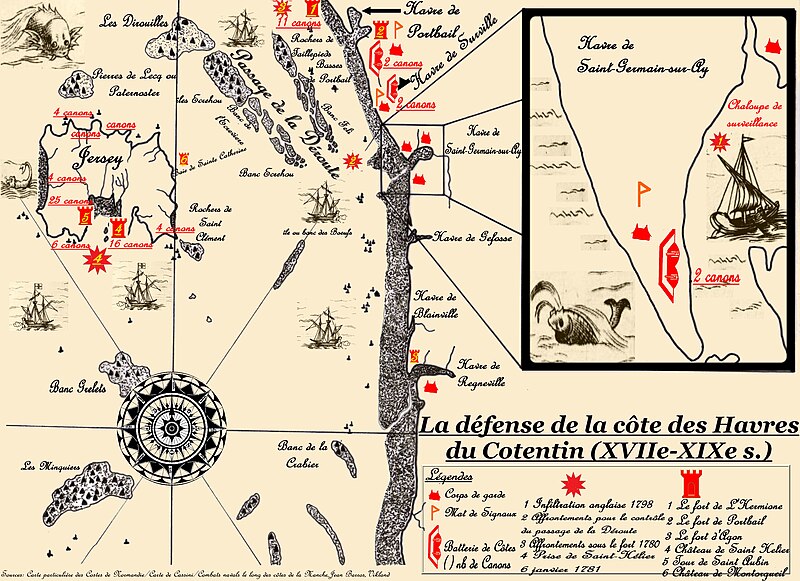
Français : J'ai tenté de synthétiser plusieurs de mes lectures sur cette carte. Elle permet de mieux comprendre l'emplacement du passage de la Déroute, mais également l'enjeu stratégique qu'il représentait aux XVII-XIXe siècle. Pour la création, j'ai utilisé une carte que j'ai dessinée puis retouchée au logiciel. J'ai également utilisé 3 fichiers Wikicommons dont je cite le nom du fichier et l'auteur :
- la rose des vents File:WInd Rose Aguiar.png de Alvesgaspar - l'étoile File:Étoile d'or.svg de Jérôme BLUM - la tour File:Map symbol historical 02.png de seamus mcgill (mcgill) |
| Date | |
| Source | Own work |
| Author | ERNOUF Guillaume |
Licensing
edit
I, the copyright holder of this work, hereby publish it under the following licenses:

|
Permission is granted to copy, distribute and/or modify this document under the terms of the GNU Free Documentation License, Version 1.2 or any later version published by the Free Software Foundation; with no Invariant Sections, no Front-Cover Texts, and no Back-Cover Texts. A copy of the license is included in the section entitled GNU Free Documentation License. |
This file is licensed under the Creative Commons Attribution-Share Alike 3.0 Unported, 2.5 Generic, 2.0 Generic and 1.0 Generic license.
- You are free:
- to share – to copy, distribute and transmit the work
- to remix – to adapt the work
- Under the following conditions:
- attribution – You must give appropriate credit, provide a link to the license, and indicate if changes were made. You may do so in any reasonable manner, but not in any way that suggests the licensor endorses you or your use.
- share alike – If you remix, transform, or build upon the material, you must distribute your contributions under the same or compatible license as the original.
You may select the license of your choice.
File history
Click on a date/time to view the file as it appeared at that time.
| Date/Time | Thumbnail | Dimensions | User | Comment | |
|---|---|---|---|---|---|
| current | 21:46, 27 July 2011 | | 4,211 × 3,060 (2.06 MB) | Saint Germinais (talk | contribs) | {{Information |Description ={{fr|1=J'ai tenté de synthétiser plusieurs de mes lectures sur cette carte. Elle permet de mieux comprendre l'emplacement du passage de la Déroute, mais également l'enjeu stratégique qu'il représentait aux XVII-XIXe si |
You cannot overwrite this file.
File usage on Commons
There are no pages that use this file.
File usage on other wikis
The following other wikis use this file:
- Usage on br.wikipedia.org
- Usage on de.wikipedia.org
- Usage on fr.wikipedia.org
- Saint-Germain-sur-Ay
- Utilisateur:Lougr'd'Ecalgrain
- Utilisateur:Les pérégrinations d'un Indiana
- Utilisateur:Saint Germinais
- Passage de la Déroute
- Wikipédia:Statistiques des anecdotes de la page d'accueil/Visibilité des anecdotes (2018)
- Discussion:Projet de pont ou de tunnel Jersey-France
- Discussion:Projet de pont ou de tunnel Jersey-France/LSV 15172
- Wikipédia:Statistiques des anecdotes de la page d'accueil/Visibilité des anecdotes (2018)/2018 08
- Projet:Aide et accueil/Twitter/Tweets/archives/août 2018
- Wikipédia:Le saviez-vous ?/Archives/2018