File:Lac Brûlé (Alberta).jpg

Size of this preview: 694 × 600 pixels. Other resolutions: 278 × 240 pixels | 556 × 480 pixels | 845 × 730 pixels.
Original file (845 × 730 pixels, file size: 274 KB, MIME type: image/jpeg)
Captions
Captions
Add a one-line explanation of what this file represents
Summary
edit.jpg&action=edit§ion=1)
| Camera location | | View this and other nearby images on: OpenStreetMap |
|---|
.jpg¶ms=053.283300_N_-117.850000_E_globe:Earth_type:camera__&language=en)
| Description |
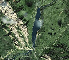
Français : Lac Brûlé, Alberta |
| Date | |
| Source | NASA WorldWind |
| Author | NASA |
Licensing
edit.jpg&action=edit§ion=2)
| This image is in the public domain because it is a screenshot from NASA’s globe software World Wind using a public domain layer, such as Blue Marble, MODIS, Landsat, SRTM, USGS or GLOBE.
|
 |
File history
Click on a date/time to view the file as it appeared at that time.
| Date/Time | Thumbnail | Dimensions | User | Comment | |
|---|---|---|---|---|---|
| current | 04:51, 13 December 2011 | | 845 × 730 (274 KB) | SamuelFreli (talk | contribs) |
You cannot overwrite this file.
File usage on Commons
There are no pages that use this file.
File usage on other wikis
The following other wikis use this file:
- Usage on bn.wikipedia.org
- Usage on fr.wikipedia.org
.jpg&oldid=552044969)