File:Lac toumiette.jpg

Size of this preview: 474 × 599 pixels. Other resolutions: 190 × 240 pixels | 380 × 480 pixels | 914 × 1,155 pixels.
Original file (914 × 1,155 pixels, file size: 364 KB, MIME type: image/jpeg)
Captions
Captions
Add a one-line explanation of what this file represents
Summary edit
| Description |
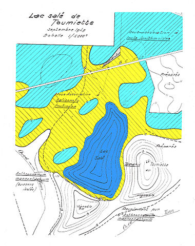
Français : Représentation schématique de la zonation des groupements végétaux sur les bords du lac de Toumiette (Oranie, Algérie ; d'après Simoneau, 1952). Cette carte montre l'importance du microrelief pour la répartition de la végétation. English: Schematic representation of the zonation of the vegetation on the lakesides of Toumiette (Oranie, Algeria; according to Simonneau, 1952). |
| Date | |
| Source | Own work |
| Author | MaximeA |
Licensing edit
I, the copyright holder of this work, hereby publish it under the following license:
This file is licensed under the Creative Commons Attribution-Share Alike 4.0 International license.
- You are free:
- to share – to copy, distribute and transmit the work
- to remix – to adapt the work
- Under the following conditions:
- attribution – You must give appropriate credit, provide a link to the license, and indicate if changes were made. You may do so in any reasonable manner, but not in any way that suggests the licensor endorses you or your use.
- share alike – If you remix, transform, or build upon the material, you must distribute your contributions under the same or compatible license as the original.
File history
Click on a date/time to view the file as it appeared at that time.
| Date/Time | Thumbnail | Dimensions | User | Comment | |
|---|---|---|---|---|---|
| current | 16:07, 7 August 2015 | | 914 × 1,155 (364 KB) | MaximeA (talk | contribs) | User created page with UploadWizard |
You cannot overwrite this file.
File usage on Commons
There are no pages that use this file.
File usage on other wikis
The following other wikis use this file: