File:Laer Urmesstischblatt von 1840.jpg

Size of this preview: 800 × 576 pixels. Other resolutions: 320 × 230 pixels | 640 × 461 pixels | 1,024 × 737 pixels | 1,280 × 921 pixels | 2,490 × 1,792 pixels.
Original file (2,490 × 1,792 pixels, file size: 2.19 MB, MIME type: image/jpeg)
Captions
Captions
Add a one-line explanation of what this file represents
Summary
edit
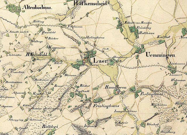
| Title |
Ausschnitt von der Gemarkung Laer vom Urmesstischblatt "Bochum" um 1840 (Messtischblatt-Nr. 4509) |
| Description |
Deutsch: "Grad Abtheilung 52°/51° der Breite, 24°/25° der Länge; Bande V. Blatt 6". Unter dem Blatt steht: "Aufgenommen und gezeichnet im Jahre 1840 von Pr.Lt.v.Negelein im 18.Inf.Rgt. u. Lt.v.Ziethen im 9.Inf.R." |
| Date | circa 1840 |
| Source | Landesvermessungsamt NRW |
| Georeferencing | If inappropriate please set warp_status = skip to hide. |
| Bibliographic data | |
| Language | German |
| Archival data | |
| Collection | Staatsbibliothek zu Berlin - Preußischer Kulturbesitz (Faksimile) |
| Dimensions | height: 43.8 cm (17.2 in); width: 44.5 cm (17.5 in) (map size) |
| Medium | colored woodcut print |
Licensing
edit
|
This is a faithful photographic reproduction of a two-dimensional, public domain work of art. The work of art itself is in the public domain for the following reason:
The official position taken by the Wikimedia Foundation is that "faithful reproductions of two-dimensional public domain works of art are public domain".
This photographic reproduction is therefore also considered to be in the public domain in the United States. In other jurisdictions, re-use of this content may be restricted; see Reuse of PD-Art photographs for details. | ||||
File history
Click on a date/time to view the file as it appeared at that time.
| Date/Time | Thumbnail | Dimensions | User | Comment | |
|---|---|---|---|---|---|
| current | 16:40, 14 October 2023 | | 2,490 × 1,792 (2.19 MB) | Heinrich Kämpchen (talk | contribs) | == {{int:filedesc}} == {{Map |title=Ausschnitt von der Gemarkung Laer vom '''Urmesstischblatt "Bochum" um 1840''' (Messtischblatt-Nr. 4509) |description={{de|"Grad Abtheilung 52°/51° der Breite, 24°/25° der Länge; Bande V. Blatt 6". Unter dem Blatt steht: "Aufgenommen und gezeichnet im Jahre 1840 von Pr.Lt.v.Negelein im 18.Inf.Rgt. u. Lt.v.Ziethen im 9.Inf.R." }} |legend= |author= |date={{other date|~|1840}} |source=Landesvermessungsamt NRW |language=de |publisher= |printer= |print date= |ins... |
You cannot overwrite this file.
File usage on Commons
There are no pages that use this file.
File usage on other wikis
The following other wikis use this file:
- Usage on de.wikipedia.org