File:Lage Krausnicker Berge.png
Size of this preview: 520 × 599 pixels. Other resolutions: 208 × 240 pixels | 417 × 480 pixels | 667 × 768 pixels | 889 × 1,024 pixels | 1,335 × 1,538 pixels.
Original file (1,335 × 1,538 pixels, file size: 310 KB, MIME type: image/png)
Captions
Captions
Add a one-line explanation of what this file represents
Summary
edit
| Description |
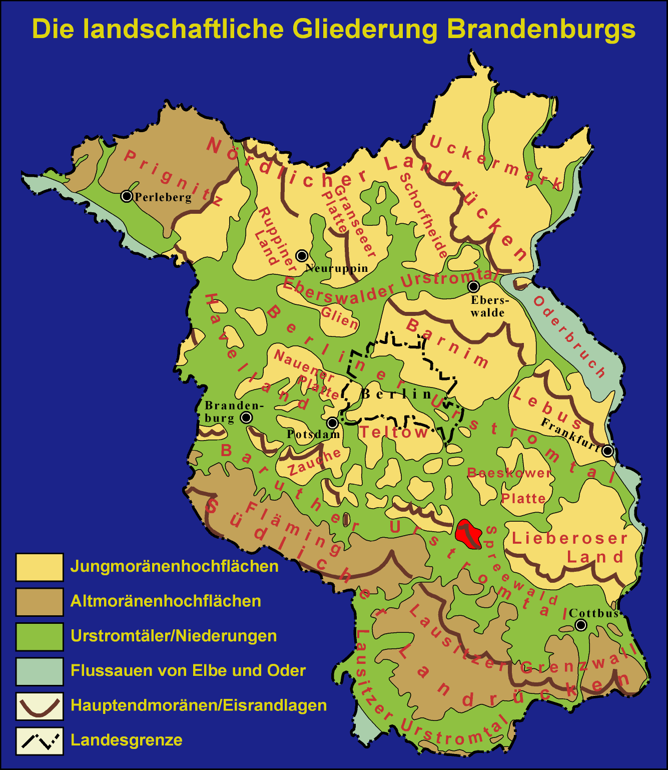
English: Location of the Krausnick hills (marked in red) in Brandenburg, Germany Deutsch: Die Lage der Krausnicker Berge (rot markiert) in Brandenburg |
| Date | |
| Source | Atlas zur Geologie von Brandenburg, Werner Stackebrandt und Volker Manhenke (pub.), Landesamt für Geowissenschaften und Rohstoffe Brandenburg (heute Landesamt für Bergbau, Geologie und Rohstoffe Brandenburg, LBGR) 2002, 2n ed., 142 pp., 43 maps, ISBN 3-9808157-0-6 |
| Author | Diagram by Grabenstedt 12:34, 27 Jul 2007 (CEST) |
Licensing
edit

|
Permission is granted to copy, distribute and/or modify this document under the terms of the GNU Free Documentation License, Version 1.2 or any later version published by the Free Software Foundation; with no Invariant Sections, no Front-Cover Texts, and no Back-Cover Texts. A copy of the license is included in the section entitled GNU Free Documentation License. |
| This file is licensed under the Creative Commons Attribution-Share Alike 3.0 Unported license. | ||
| ||
| This licensing tag was added to this file as part of the GFDL licensing update. |
Original upload log
edit
The original description page was here. All following user names refer to de.wikipedia.
- 2007-07-27 10:34 Grabenstedt 1335×1538× (316992 bytes) {{Information |Beschreibung = Die Lage der Krausnicker Berge in Brandenburg |Quelle = [[Bild:Uebersicht Brandenburg.png]] |Urheber = Zeichnung von ~~~~ |Datum = 27.07.2007 |Genehmigung = |Andere Versionen = |Anmerkungen = }}
File history
Click on a date/time to view the file as it appeared at that time.
| Date/Time | Thumbnail | Dimensions | User | Comment | |
|---|---|---|---|---|---|
| current | 17:30, 1 November 2013 | | 1,335 × 1,538 (310 KB) | Bermicourt (talk | contribs) | {{Information |Description ={{en|1={{Information |Description={{de|Die Lage der Krausnicker Berge (rot markiert) in Brandenburg}} |Source=Transferred from [http://de.wikipedia.org de.wikipedia]<br/> (Original text : ''''Atlas zur Geologie von Brande... |
You cannot overwrite this file.
File usage on Commons
There are no pages that use this file.
File usage on other wikis
The following other wikis use this file:
- Usage on de.wikipedia.org
- Usage on en.wikipedia.org