File:Lage der Hallertau in Bayern.png

Size of this preview: 588 × 599 pixels. Other resolutions: 236 × 240 pixels | 471 × 480 pixels | 754 × 768 pixels | 1,052 × 1,072 pixels.
Original file (1,052 × 1,072 pixels, file size: 2.53 MB, MIME type: image/png)
Captions
Captions
Add a one-line explanation of what this file represents
Summary edit
| Description |
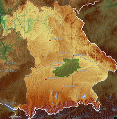
Deutsch: Lagekarte der Hallertau
}
|
| Date | |
| Source | Karte von http://de.wikipedia.org/wiki/Bild:Deutschland_topo.jpg bearbeitet |
| Author | Benutzer:Eppasandas |
Licensing edit

|
Permission is granted to copy, distribute and/or modify this document under the terms of the GNU Free Documentation License, Version 1.2 or any later version published by the Free Software Foundation; with no Invariant Sections, no Front-Cover Texts, and no Back-Cover Texts. A copy of the license is included in the section entitled GNU Free Documentation License. |
| This file is licensed under the Creative Commons Attribution-Share Alike 3.0 Unported license. | ||
| ||
| This licensing tag was added to this file as part of the GFDL licensing update. |
Original upload log edit
Transferred from de.wikipedia to Commons by Dede2.
The original description page was here. All following user names refer to de.wikipedia.
- 2006-10-22 17:21 Eppasandas 1052×1072× (2655800 bytes) *Beschreibung: Lagekarte der Hallertau *Quelle: Karte von http://de.wikipedia.org/wiki/Bild:Deutschland_topo.jpg bearbeitet *Fotograf oder Zeichner: [[Benutzer:Eppasandas]] *Datum: Oktober 2006 *Andere Versionen
- 2006-10-22 10:19 Eppasandas 1052×1072× (2679688 bytes) *Beschreibung: Lagekarte der Hallertau *Quelle: Karte von http://de.wikipedia.org/wiki/Bild:Deutschland_topo.jpg bearbeitet *Fotograf oder Zeichner: [[Benutzer:Eppasandas]] *Datum: Oktober 2006 *Andere Versionen
- 2006-10-12 11:19 Eppasandas 213×219× (18732 bytes) *Beschreibung: Lagekarte der Hallertau *Quelle: Karte von http://en.wikipedia.org/wiki/Image:BlankMap-GermanyStates.png bearbeitet *Fotograf oder Zeichner: [[Benutzer:Eppasandas]] *Datum: Oktober 2006 *Andere Versionen
File history
Click on a date/time to view the file as it appeared at that time.
| Date/Time | Thumbnail | Dimensions | User | Comment | |
|---|---|---|---|---|---|
| current | 16:15, 23 December 2010 | | 1,052 × 1,072 (2.53 MB) | Dede2 (talk | contribs) | {{Information |Description={{de|Lagekarte der Hallertau *Andere Versionen {| | Bei der Erstellung der Landkarte wurden die '''Generic Mapping Tools''' verwendet: http://gmt.soest.hawaii.edu/ Für das Relief - falls vorhanden - wurde(n) einer oder mehrer |
You cannot overwrite this file.
File usage on Commons
The following page uses this file:
File usage on other wikis
The following other wikis use this file:
- Usage on cs.wikipedia.org
- Usage on de.wikipedia.org
- Usage on en.wikipedia.org
- Usage on eo.wikipedia.org
- Usage on es.wikipedia.org
- Usage on fr.wikipedia.org
- Usage on it.wikipedia.org
- Usage on pl.wikipedia.org
- Usage on www.wikidata.org