File:Lage von Freising.png

Size of this preview: 601 × 599 pixels. Other resolutions: 241 × 240 pixels | 481 × 480 pixels | 770 × 768 pixels | 1,027 × 1,024 pixels | 1,756 × 1,751 pixels.
Original file (1,756 × 1,751 pixels, file size: 903 KB, MIME type: image/png)
Captions
Captions
Add a one-line explanation of what this file represents
Summary
edit
| Description |
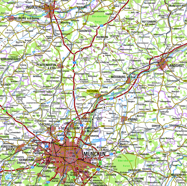
Deutsch: Umgebung von Freising 1:500.000 |
| Date | (UTC) |
| Source |
This file was derived from: Topografische Karte Bayern.tif:  |
| Author |
|
| This is a retouched picture, which means that it has been digitally altered from its original version. Modifications: Ausschnitt aus Karte. The original can be viewed here: Topografische Karte Bayern.tif:
|
Licensing
edit
I, the copyright holder of this work, hereby publish it under the following license:
This file is licensed under the Creative Commons Attribution 3.0 Germany license.
- You are free:
- to share – to copy, distribute and transmit the work
- to remix – to adapt the work
- Under the following conditions:
- attribution – You must give appropriate credit, provide a link to the license, and indicate if changes were made. You may do so in any reasonable manner, but not in any way that suggests the licensor endorses you or your use.

Original upload log
edit
This image is a derivative work of the following images:
- File:Topografische_Karte_Bayern.tif licensed with Cc-by-3.0-de
- 2012-02-08T11:34:04Z NordNordWest 3450x3613 (12485140 Bytes) lower res
- 2012-02-08T11:25:22Z NordNordWest 7200x7540 (54307384 Bytes) == {{int:filedesc}} == {{Information |Description ={{de|1=Topografische Karte 1:500.000 von Bayern}} {{en|1=Topographical map 1:500.000 of Bavaria}} |Source =http://vermessung.bayern.de/opendata |Author =Da
Uploaded with derivativeFX
File history
Click on a date/time to view the file as it appeared at that time.
| Date/Time | Thumbnail | Dimensions | User | Comment | |
|---|---|---|---|---|---|
| current | 17:32, 29 December 2012 | | 1,756 × 1,751 (903 KB) | Vuxi (talk | contribs) | höhere Auflösung |
| 14:02, 28 December 2012 |  | 838 × 830 (339 KB) | Vuxi (talk | contribs) | == {{int:filedesc}} == {{Information |Description={{de|1=Umgebung von Freising 1:500.000 }} |Source={{Derived from|Topografische_Karte_Bayern.tif|display=50}} |Date=2012-12-28 14:00 (UTC) |Author=*File:Topografische_Karte_Bayern.tif: Datenquelle:... |
You cannot overwrite this file.
File usage on Commons
There are no pages that use this file.
File usage on other wikis
The following other wikis use this file:
- Usage on de.wikipedia.org