File:Lago de Furnas 2.jpg
Size of this preview: 800 × 450 pixels. Other resolutions: 320 × 180 pixels | 640 × 360 pixels | 1,024 × 576 pixels | 1,280 × 720 pixels | 2,560 × 1,439 pixels | 3,653 × 2,054 pixels.
Original file (3,653 × 2,054 pixels, file size: 3.97 MB, MIME type: image/jpeg)
Captions
Captions
Add a one-line explanation of what this file represents
Summary
edit
| Description |
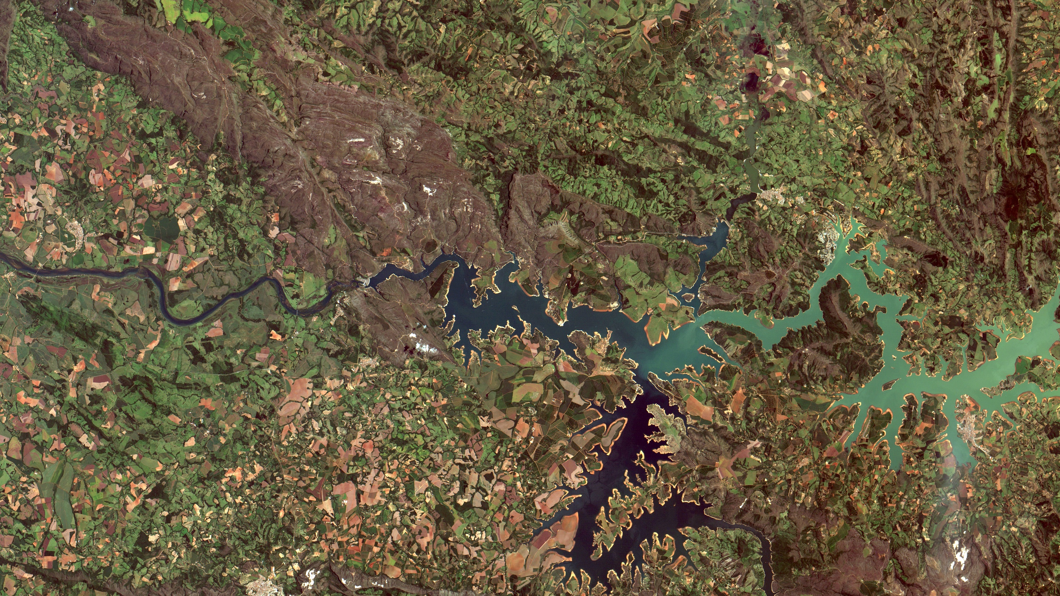
English: Lago de Furnas no Rio Grande em Minas Gerais, entre Capitólio ao norte, e Guapé ao sul. Com 29% do seu volume útil (ANA, link abaixo) nessa imagem de ontem, a superfície da água aparece em azul escuro no canto inferior esq. e em turquesa, onde mais eutrofizada. Em marrom claro e escuro cerrado. Em verde claro pastagens e culturas agrícolas. Em verde escuro matas ciliares e reflorestamentos. Também em verde, cafezais, ao sul do lago, em Guapé. Solos expostos em laranja. Área urbana de Capitólio em salpicado alaranjado no alto ao centro da imagem, e do balneário Escarpas do Lago em salpicado branco, a sudeste de Capitólio, às margens do lago / Furnas Lake on Grande River at Minas Gerais., between Capitólio to the north and Guapé to the south. With 29% of its effective volume (ANA, link bellow) at yesterday´s image, water surface appears in deep blue at image left bottom and in turquoise where more eutrophic. Savannas in dark and light brown. Pastures and crops in light green. In dark green riparian forests and afforestation. Also in green coffee plantations, south of the lake, at Guapé. Exposed soils in orange. Capitólio urban area in orangeish saltpepper, and whiteish at Escarpas do Lago by the lake gated community, southeast of Capitolio.
+info: ANA - volume / cota
Imagem / Image CBERS4 MUX Reservatório da UHE Furnas / Furnas Dam no Rio Grande em Capitólio e Guapé Coordenadas do centro da imagem / Image center: 20°41'33.0"S 46°02'57.6"W Data / Date: 24-02-2019 / 2019-24-02 RGB 765 (cor verdadeira / true color) Cena / Scene: 155 / 123 Autor / Author: Oton Barros (DSR/OBT/INPE) Imagem em HD / HD Image Visite-nos / Visit us: www.dsr.inpe.br |
| Date | |
| Source | https://www.flickr.com/photos/153282474@N02/40243886613/ |
| Author | Coordenação-Geral de Observação da Terra/INPE |
Licensing
edit
This file is licensed under the Creative Commons Attribution-Share Alike 2.0 Generic license.
- You are free:
- to share – to copy, distribute and transmit the work
- to remix – to adapt the work
- Under the following conditions:
- attribution – You must give appropriate credit, provide a link to the license, and indicate if changes were made. You may do so in any reasonable manner, but not in any way that suggests the licensor endorses you or your use.
- share alike – If you remix, transform, or build upon the material, you must distribute your contributions under the same or compatible license as the original.
| This image was originally posted to Flickr by Coordenação-Geral de Observação da Terra/INPE at https://flickr.com/photos/153282474@N02/40243886613. It was reviewed on 9 April 2020 by FlickreviewR 2 and was confirmed to be licensed under the terms of the cc-by-sa-2.0. |
File history
Click on a date/time to view the file as it appeared at that time.
| Date/Time | Thumbnail | Dimensions | User | Comment | |
|---|---|---|---|---|---|
| current | 10:13, 9 April 2020 | | 3,653 × 2,054 (3.97 MB) | Jo-Jo Eumerus (talk | contribs) | Uploaded a work by Coordenação-Geral de Observação da Terra/INPE from https://www.flickr.com/photos/153282474@N02/40243886613/ with UploadWizard |
You cannot overwrite this file.
File usage on Commons
The following page uses this file:
- File:UHE Dam Furnas, região de Capitólio MG (40243886613).jpg (file redirect)
.jpg&redirect=no)
File usage on other wikis
The following other wikis use this file:
- Usage on de.wikipedia.org