File:Lagtingsvalg 2022.svg

Size of this PNG preview of this SVG file: 433 × 599 pixels. Other resolutions: 173 × 240 pixels | 347 × 480 pixels | 555 × 768 pixels | 740 × 1,024 pixels | 1,481 × 2,048 pixels | 820 × 1,134 pixels.
Original file (SVG file, nominally 820 × 1,134 pixels, file size: 125 KB)
Captions
Captions
Add a one-line explanation of what this file represents
Summary edit
| Description |
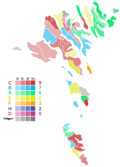
English: Map of the 2022 Faroese Løgting election, showing the largest party in each polling area.
Dansk: Kort over det største parti i hvert afstemningsområde ved Færøernes lagtingsvalg i 2022. |
| Date | |
| Source | Own work |
| Author | Gust Justice |
| Other versions |
File:Lagtingsvalg 2022.svg has 3 translations.
|


Licensing edit
I, the copyright holder of this work, hereby publish it under the following license:
This file is licensed under the Creative Commons Attribution-Share Alike 4.0 International license.
- You are free:
- to share – to copy, distribute and transmit the work
- to remix – to adapt the work
- Under the following conditions:
- attribution – You must give appropriate credit, provide a link to the license, and indicate if changes were made. You may do so in any reasonable manner, but not in any way that suggests the licensor endorses you or your use.
- share alike – If you remix, transform, or build upon the material, you must distribute your contributions under the same or compatible license as the original.
File history
Click on a date/time to view the file as it appeared at that time.
| Date/Time | Thumbnail | Dimensions | User | Comment | |
|---|---|---|---|---|---|
| current | 19:17, 14 March 2024 | | 820 × 1,134 (125 KB) | Gust Justice (talk | contribs) | Reverted to version as of 23:58, 8 December 2022 (UTC) The English translation is wrong. The gray colors are used to indicate polling areas for which two or more parties were tied, not independent candidates. |
| 01:56, 13 March 2024 |  | 820 × 1,134 (138 KB) | PoliticsMaps (talk | contribs) | File uploaded using svgtranslate tool (https://svgtranslate.toolforge.org/). Added translation for en. | |
| 01:56, 13 March 2024 |  | 820 × 1,134 (138 KB) | PoliticsMaps (talk | contribs) | File uploaded using svgtranslate tool (https://svgtranslate.toolforge.org/). Added translation for da. | |
| 01:54, 13 March 2024 |  | 820 × 1,134 (138 KB) | PoliticsMaps (talk | contribs) | File uploaded using svgtranslate tool (https://svgtranslate.toolforge.org/). Added translation for en. | |
| 23:58, 8 December 2022 |  | 820 × 1,134 (125 KB) | Gust Justice (talk | contribs) | Removed labels. | |
| 23:56, 8 December 2022 |  | 820 × 1,134 (125 KB) | Gust Justice (talk | contribs) | Final results on election night | |
| 22:35, 8 December 2022 |  | 820 × 1,134 (126 KB) | Gust Justice (talk | contribs) | Results so far | |
| 21:36, 8 December 2022 |  | 820 × 1,134 (126 KB) | Gust Justice (talk | contribs) | Results so far | |
| 21:06, 8 December 2022 |  | 820 × 1,134 (126 KB) | Gust Justice (talk | contribs) | Results so far | |
| 20:45, 17 November 2022 |  | 820 × 1,134 (126 KB) | Gust Justice (talk | contribs) | Uploaded own work with UploadWizard |
You cannot overwrite this file.
File usage on Commons
The following 5 pages use this file:
File usage on other wikis
The following other wikis use this file:
- Usage on ca.wikipedia.org
- Usage on da.wikipedia.org
- Usage on en.wikipedia.org
- Usage on es.wikipedia.org
- Usage on fi.wikipedia.org
- Usage on fo.wikipedia.org
- Usage on it.wikipedia.org
- Usage on no.wikipedia.org