File:Lake Michigan Coastal Area from Skylab space station during Skylab 3 mission.jpg

Size of this preview: 595 × 600 pixels. Other resolutions: 238 × 240 pixels | 476 × 480 pixels | 762 × 768 pixels | 1,015 × 1,024 pixels | 2,031 × 2,048 pixels | 2,975 × 3,000 pixels.
Original file (2,975 × 3,000 pixels, file size: 2.76 MB, MIME type: image/jpeg)
Captions
Captions
Add a one-line explanation of what this file represents
Summary
edit
| Description |
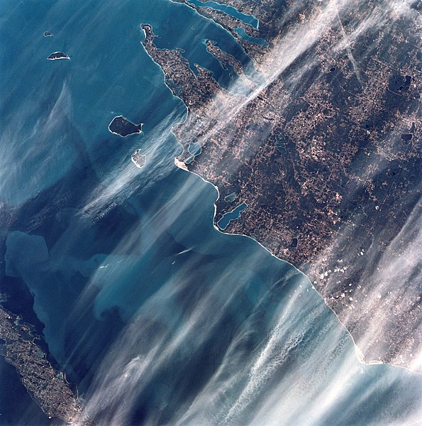
English: SL3-34-302 (July-September 1973) --- A vertical view of the Lake Michigan coastal area of northern Michigan as photographed from Earth orbit by one of the Itek-furnished S190-A Multispectral Photographic Facility Experiment aboard the Skylab space station. The view extends across Lake Michigan to Wisconsin's Green Bay. The two-fingered body of water is Grand Traverse Bay. Traverse City, Cadillac and Manistee can be seen in this photograph. Federal agencies participating with NASA on the EREP project are the Departments of Agriculture, Commerce, Interior, the Environmental Protection Agency and the Corps of Engineers. All EREP photography is available to the public through the Department of Interior's Earth Resources Observations Systems Data Center, Sioux Falls, South Dakota, 57198. |
| Date | |
| Source | https://www.flickr.com/photos/nasa2explore/11309607133/in/album-72157638530137524/ |
| Author | NASA |
Licensing
edit
| This file is in the public domain in the United States because it was solely created by NASA. NASA copyright policy states that "NASA material is not protected by copyright unless noted". (See Template:PD-USGov, NASA copyright policy page or JPL Image Use Policy.) | ||
 |
Warnings:
|
File history
Click on a date/time to view the file as it appeared at that time.
| Date/Time | Thumbnail | Dimensions | User | Comment | |
|---|---|---|---|---|---|
| current | 16:49, 3 July 2020 | | 2,975 × 3,000 (2.76 MB) | Andrej-airliner (talk | contribs) | Uploaded a work by NASA from https://www.flickr.com/photos/nasa2explore/11309607133/in/album-72157638530137524/ with UploadWizard |
You cannot overwrite this file.
File usage on Commons
There are no pages that use this file.
File usage on other wikis
The following other wikis use this file:
- Usage on sk.wikipedia.org