File:Lake Pepin Half-Breed.png

Size of this preview: 800 × 558 pixels. Other resolutions: 320 × 223 pixels | 640 × 446 pixels | 955 × 666 pixels.
Original file (955 × 666 pixels, file size: 1.31 MB, MIME type: image/png)
Captions
Captions
Add a one-line explanation of what this file represents
Summary
edit
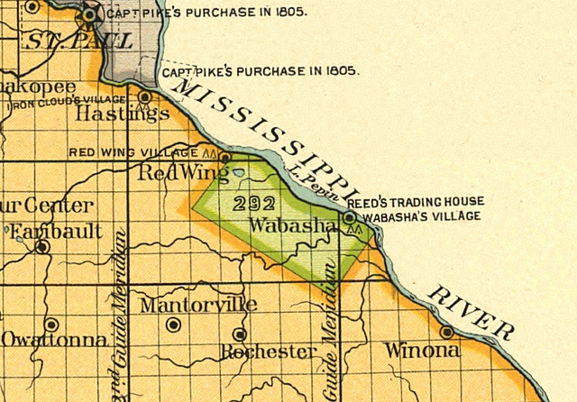
| Description | Details from 18th Annual Report, Plate 104—Minnesota, 1: Map of the w:Half-Breed Tract in Minnesota, a reservation designated for individuals of mixed American Indian and European descent. This reservation was designated in the 1830 w:Treaty of Prarie du Chien. |
| Date | |
| Source | Indian Land Cessions in the United States, 1784 to 1894: Minnesota map |
| Author |
Charles C. Royce, editor Published by United States Bureau of American Ethnology, Washington, DC Lithography by A. Moen & Co., Baltimore, MD |
| Other versions |
 |
| Camera location | | View this and other nearby images on: OpenStreetMap |
|---|
Licensing
edit
| This work is from the Library of Congress. According to the library, there are no known copyright restrictions on the use of this work. |  |
File history
Click on a date/time to view the file as it appeared at that time.
| Date/Time | Thumbnail | Dimensions | User | Comment | |
|---|---|---|---|---|---|
| current | 14:33, 30 January 2008 | | 955 × 666 (1.31 MB) | Elkman (talk | contribs) | {{Information |Description=Map of the w:Half-Breed Tract in Minnesota, a reservation designated for individuals of mixed American Indian and European descent. This reservation was designated in the 1830 w:Treaty of Prarie du Chien. |Sour |
You cannot overwrite this file.
File usage on Commons
There are no pages that use this file.
File usage on other wikis
The following other wikis use this file:
- Usage on en.wikipedia.org