File:Lake bonneville map.svg

Size of this PNG preview of this SVG file: 663 × 570 pixels. Other resolutions: 279 × 240 pixels | 558 × 480 pixels | 893 × 768 pixels | 1,191 × 1,024 pixels | 2,382 × 2,048 pixels.
Original file (SVG file, nominally 663 × 570 pixels, file size: 352 KB)
Captions
Captions
Add a one-line explanation of what this file represents
|
Summary edit
| Description |
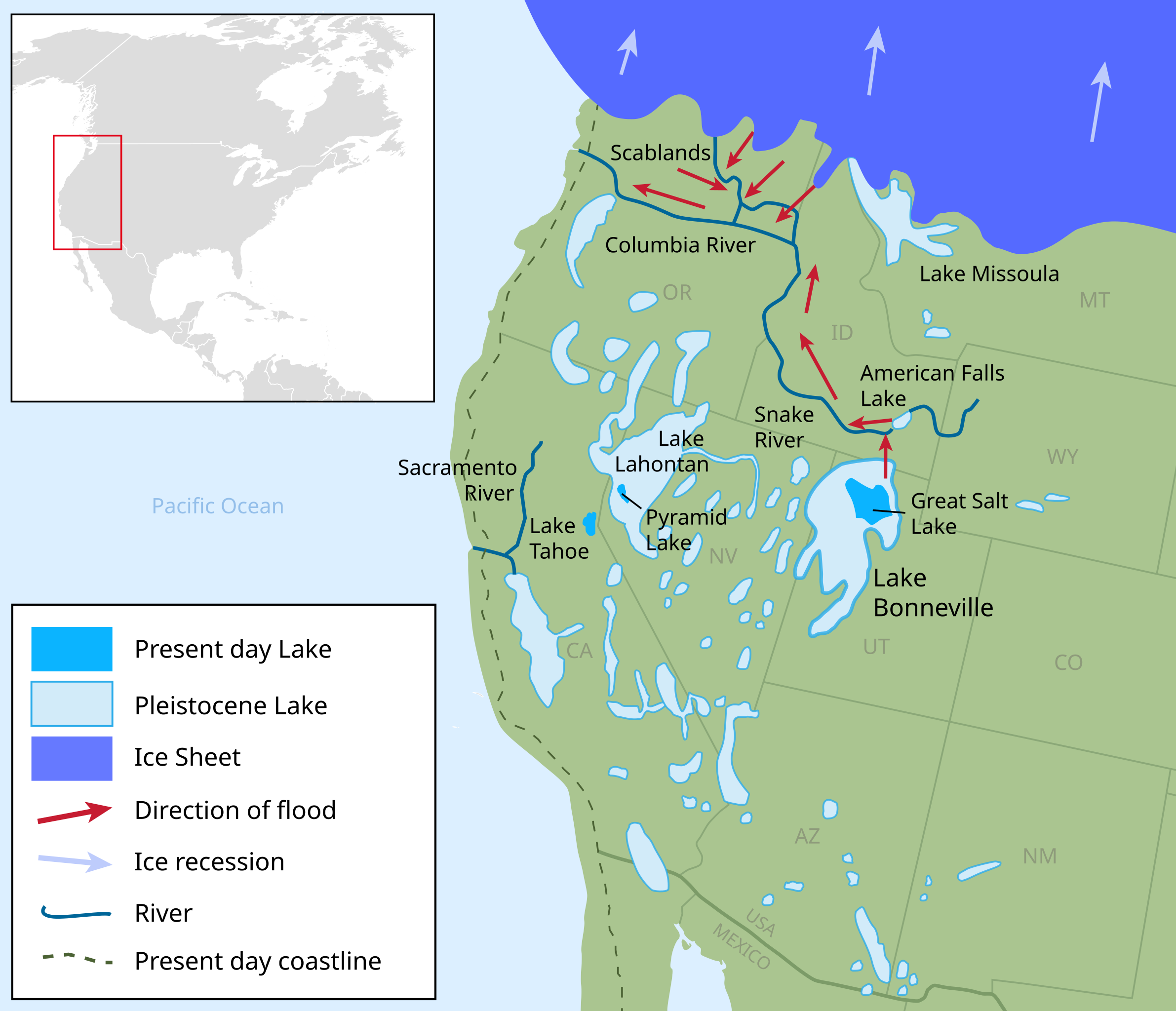
English: Pleistocene epoch map showing the extent of the Lake Bonneville Flood and Pleistocene lakes in northwestern United States around 14.5000 radiocarbon years (~17,500 calendar years) before present.
Ice Sheet
Pleistocene Lake
Present day Lake
Direction of flood |
| Date | |
| Source |
Own work.
W3C-validity not checked. |
| Author | Fallschirmjäger |
Licensing edit
I, the copyright holder of this work, hereby publish it under the following license:
This file is licensed under the Creative Commons Attribution-Share Alike 3.0 Unported license.
- You are free:
- to share – to copy, distribute and transmit the work
- to remix – to adapt the work
- Under the following conditions:
- attribution – You must give appropriate credit, provide a link to the license, and indicate if changes were made. You may do so in any reasonable manner, but not in any way that suggests the licensor endorses you or your use.
- share alike – If you remix, transform, or build upon the material, you must distribute your contributions under the same or compatible license as the original.
File history
Click on a date/time to view the file as it appeared at that time.
| Date/Time | Thumbnail | Dimensions | User | Comment | |
|---|---|---|---|---|---|
| current | 22:29, 11 September 2014 | | 663 × 570 (352 KB) | Liandrei (talk | contribs) | Fixed alignment |
| 22:27, 11 September 2014 |  | 663 × 570 (352 KB) | Liandrei (talk | contribs) | Removed ambiguous arrows from Lake Missoula and those pointing from the Sacramento River to Lake Lahontan per POTD/2014-09-15 discussion. | |
| 11:12, 21 April 2013 |  | 663 × 570 (352 KB) | Liandrei (talk | contribs) | Fixed Mexico | |
| 11:04, 21 April 2013 |  | 666 × 570 (320 KB) | Liandrei (talk | contribs) | Widened and moved boxes to left | |
| 22:52, 20 March 2013 |  | 650 × 570 (395 KB) | Liandrei (talk | contribs) | tiny tweak | |
| 01:27, 20 March 2013 |  | 650 × 570 (395 KB) | Liandrei (talk | contribs) | tweaks | |
| 01:21, 13 March 2013 |  | 650 × 570 (521 KB) | Liandrei (talk | contribs) | forgot to remove error from inkscape again... | |
| 01:19, 13 March 2013 |  | 650 × 570 (521 KB) | Liandrei (talk | contribs) | tweakage | |
| 01:09, 13 March 2013 |  | 650 × 570 (521 KB) | Liandrei (talk | contribs) | Added coastline & made valid svg | |
| 05:01, 12 March 2013 |  | 650 × 570 (396 KB) | Orionist (talk | contribs) | Fixed errors to validate SVG, removed white rectangles and cropped extraneous parts of the maps, reduced file size, and did some other cosmetic changes. |
You cannot overwrite this file.
File usage on Commons
The following 2 pages use this file:
File usage on other wikis
The following other wikis use this file:
- Usage on bg.wikipedia.org
- Usage on ca.wikipedia.org
- Usage on en.wikipedia.org
- Great Salt Lake
- Lake Bonneville
- Pyramid Lake (Nevada)
- Lake Lahontan
- Pluvial lake
- Last Glacial Period
- Tollmann's bolide hypothesis
- Talk:Lake Bonneville
- Wikipedia:Featured pictures/Diagrams, drawings, and maps/Maps
- Bonneville flood
- User talk:Orionist/Archives
- User talk:TCO
- Wikipedia:Featured pictures thumbs/34
- User talk:Liandrei/2013
- Wikipedia:Featured picture candidates/Lake Bonneville map
- Wikipedia:Featured picture candidates/April-2013
- Wikipedia:Picture of the day/September 2014
- Template:POTD/2014-09-15
- User talk:Liandrei/2014
- Wikipedia:Main Page history/2014 September 15
- Usage on fa.wikipedia.org
- Usage on fr.wikipedia.org
- Usage on it.wikipedia.org
- Usage on nn.wikipedia.org
- Usage on no.wikipedia.org
- Usage on pl.wikipedia.org
- Usage on pt.wikipedia.org
- Usage on ru.wikipedia.org
- Usage on sv.wikipedia.org
- Usage on uk.wikipedia.org
- Usage on vec.wikipedia.org
- Usage on vi.wikipedia.org
- Usage on www.wikidata.org