File:Landslide in Alta, Norway.jpg

Original file (3,513 × 2,533 pixels, file size: 1.19 MB, MIME type: image/jpeg)
Captions
Captions
Summary
edit
| Description |
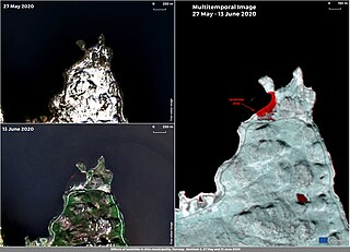
English: A destructive landslide of 3 hectares swept eight buildings into the sea on 3 June. The landslide occurred in the Alta Municipality, a municipality at the northern tip of Norway. There were no injuries or fatalities, even though there were two people in the cabins at the time of the landslide who managed to escape. The cause of the slide is not yet known, but it could be related to the saturation of the soil caused by the melting snow and heavy rainfall in the area. This mosaic, obtained with images acquired by the Copernicus Sentinel-2 satellite on 27 May and 13 June, shows the area affected by the landslide before (top left) and after the event (top right), and a multitemporal image (right) with the areas affected by the slide appearing in red obtained by combining the before and after data. Data derived by Copernicus Sentinel-1 and Sentinel-2 satellites are suitable for mapping and monitoring landslides. |
| Date | 16 June 2020 (upload date) |
| Source | Landslide in Alta, Norway |
| Author | European Union , Copernicus Sentinel-2 imagery |
Licensing
edit

|
This image contains data from a satellite in the Copernicus Programme, such as Sentinel-1, Sentinel-2 or Sentinel-3. Attribution is required when using this image.
Attribution: Contains modified Copernicus Sentinel data 2020
The use of Copernicus Sentinel Data is regulated under EU law (Commission Delegated Regulation (EU) No 1159/2013 and Regulation (EU) No 377/2014). Relevant excerpts:
Free access shall be given to GMES dedicated data [...] made available through GMES dissemination platforms [...].
Access to GMES dedicated data [...] shall be given for the purpose of the following use in so far as it is lawful:
GMES dedicated data [...] may be used worldwide without limitations in time.
GMES dedicated data and GMES service information are provided to users without any express or implied warranty, including as regards quality and suitability for any purpose. |
File history
Click on a date/time to view the file as it appeared at that time.
| Date/Time | Thumbnail | Dimensions | User | Comment | |
|---|---|---|---|---|---|
| current | 21:38, 24 July 2023 | | 3,513 × 2,533 (1.19 MB) | OptimusPrimeBot (talk | contribs) | #Spacemedia - Upload of https://www.copernicus.eu/system/files/2020-06/image_day/Alta_landslide_row.jpg via Commons:Spacemedia |
You cannot overwrite this file.
File usage on Commons
The following page uses this file:
- File:Landslide in Alta, Norway (landslide-alta-norway).jpg (file redirect)
.jpg&redirect=no)