File:Langmahdhalde 4.png

Size of this preview: 800 × 340 pixels. Other resolutions: 320 × 136 pixels | 640 × 272 pixels | 1,024 × 436 pixels | 1,280 × 545 pixels | 2,548 × 1,084 pixels.
Original file (2,548 × 1,084 pixels, file size: 2.17 MB, MIME type: image/png)
Captions
Captions
Add a one-line explanation of what this file represents
Summary edit
| Description |
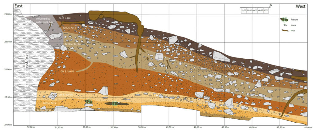
Deutsch: Die Stratigraphie der Langmahdhalde aus den Grabungsjahren 2016 bis 2018. Dies ist das Südprofil der Fundstelle an der y-Koordinate 37 (die von Ost nach West verläuft). Verbrennungsmerkmale, Steine und Wurzeln können mit der Legende oben rechts identifiziert werden. Weitere Informationen finden Sie in Tabelle 1. GH = geologischer Horizont; AH = archäologischer Horizont. Abbildung von Alexander Janas
English: The stratigraphy of Langmahdhalde from excavation years 2016 to 2018. This is the southern profile of the site at the y-coordinate 37 (which runs east to west). Combustion features, stones, and roots can be identified using the key in the upper right. Further information can be found in Table 1. GH = geological horizon; AH = archaeological horizon. Figure by Alexander Janas |
| Date | |
| Source | Gillian L. Wong, Britt M. Starkovich, Dorothée G. Drucker et al. New perspectives on human subsistence during the Magdalenian in the Swabian Jura, Germany. Archaeol Anthropol Sci 12, 217 (2020). https://doi.org/10.1007/s12520-020-01119-w |
| Author | Alexander Janas |
| Permission (Reusing this file) |
Open Access This article is licensed under a Creative Commons Attribution 4.0 International License, which permits use, sharing, adaptation, distribution and reproduction in any medium or format, as long as you give appropriate credit to the original author(s) and the source, provide a link to the Creative Commons licence, and indicate if changes were made. The images or other third party material in this article are included in the article's Creative Commons licence, unless indicated otherwise in a credit line to the material. If material is not included in the article's Creative Commons licence and your intended use is not permitted by statutory regulation or exceeds the permitted use, you will need to obtain permission directly from the copyright holder. To view a copy of this licence, visit https://creativecommons.org/licenses/by/4.0/. |
Licensing edit
This file is licensed under the Creative Commons Attribution 4.0 International license.
- You are free:
- to share – to copy, distribute and transmit the work
- to remix – to adapt the work
- Under the following conditions:
- attribution – You must give appropriate credit, provide a link to the license, and indicate if changes were made. You may do so in any reasonable manner, but not in any way that suggests the licensor endorses you or your use.
File history
Click on a date/time to view the file as it appeared at that time.
| Date/Time | Thumbnail | Dimensions | User | Comment | |
|---|---|---|---|---|---|
| current | 10:00, 28 April 2024 | | 2,548 × 1,084 (2.17 MB) | Thilo Parg (talk | contribs) | {{Information |Description=Die Stratigraphie der Langmahdhalde aus den Grabungsjahren 2016 bis 2018. Dies ist das Südprofil der Fundstelle an der y-Koordinate 37 (die von Ost nach West verläuft). Verbrennungsmerkmale, Steine und Wurzeln können mit der Legende oben rechts identifiziert werden. Weitere Informationen finden Sie in Tabelle 1. GH = geologischer Horizont; AH = archäologischer Horizont. Abbildung von Alexander Janas |Source=Gillian L. Wong, Britt M. Starkovich, Dorothée G. Drucker... |
You cannot overwrite this file.
File usage on Commons
The following 3 pages use this file:
File usage on other wikis
The following other wikis use this file:
- Usage on de.wikipedia.org