File:Langmahdhalde 5.png
Size of this preview: 600 × 599 pixels. Other resolutions: 240 × 240 pixels | 480 × 480 pixels | 986 × 985 pixels.
Original file (986 × 985 pixels, file size: 212 KB, MIME type: image/png)
Captions
Captions
Add a one-line explanation of what this file represents
Summary edit
| Description |
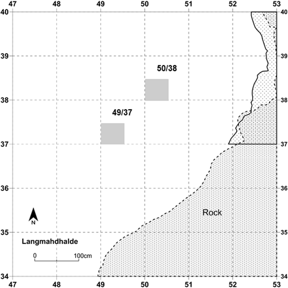
Deutsch: Übersicht über die Ausgrabungsquadranten der Langmahdhalde. Jeder Quadrant hat eine Abmessung von 1 × 1 m und ist nach den Koordinaten seiner südwestlichen Ecke benannt. Die gepunkteten Bereiche auf der rechten Seite der Abbildung zeigen den Felsüberhang. Die 50 × 50 cm großen südwestlichen Subquadranten, grau hervorgehoben, sind die Subquadranten, die für die taphonomische Analyse der Mikrofauna ausgewählt wurden (49/37 für GH3 und 50/38 für alle anderen Horizonte). Abbildung von Mohsen Zeidi
English: Overview of the excavation quadrants at Langmahdhalde. Each quadrant is 1 × 1 m in dimension and named based on the coordinates of its southwestern corner. The dotted areas on the right side of the figure indicate the rock shelter. The 50 × 50 cm southwestern subquadrants, highlighted in gray, are the subquadrants selected for the taphonomic analysis of the microfauna (49/37 for GH3 and 50/38 for all other horizons). Figure by Mohsen Zeidi |
| Date | |
| Source | Gillian L. Wong, Britt M. Starkovich, Dorothée G. Drucker et al. New perspectives on human subsistence during the Magdalenian in the Swabian Jura, Germany. Archaeol Anthropol Sci 12, 217 (2020). https://doi.org/10.1007/s12520-020-01119-w |
| Author | Mohsen Zeidi |
| Permission (Reusing this file) |
Open Access This article is licensed under a Creative Commons Attribution 4.0 International License, which permits use, sharing, adaptation, distribution and reproduction in any medium or format, as long as you give appropriate credit to the original author(s) and the source, provide a link to the Creative Commons licence, and indicate if changes were made. The images or other third party material in this article are included in the article's Creative Commons licence, unless indicated otherwise in a credit line to the material. If material is not included in the article's Creative Commons licence and your intended use is not permitted by statutory regulation or exceeds the permitted use, you will need to obtain permission directly from the copyright holder. To view a copy of this licence, visit https://creativecommons.org/licenses/by/4.0/. |
Licensing edit
This file is licensed under the Creative Commons Attribution 4.0 International license.
- You are free:
- to share – to copy, distribute and transmit the work
- to remix – to adapt the work
- Under the following conditions:
- attribution – You must give appropriate credit, provide a link to the license, and indicate if changes were made. You may do so in any reasonable manner, but not in any way that suggests the licensor endorses you or your use.
File history
Click on a date/time to view the file as it appeared at that time.
| Date/Time | Thumbnail | Dimensions | User | Comment | |
|---|---|---|---|---|---|
| current | 10:05, 28 April 2024 | | 986 × 985 (212 KB) | Thilo Parg (talk | contribs) | {{Information |Description=Übersicht über die Ausgrabungsquadranten der Langmahdhalde. Jeder Quadrant hat eine Abmessung von 1 × 1 m und ist nach den Koordinaten seiner südwestlichen Ecke benannt. Die gepunkteten Bereiche auf der rechten Seite der Abbildung zeigen den Felsüberhang. Die 50 × 50 cm großen südwestlichen Subquadranten, grau hervorgehoben, sind die Subquadranten, die für die taphonomische Analyse der Mikrofauna ausgewählt wurden (49/37 für GH3 und 50/38 für alle anderen Horizonte)... |
You cannot overwrite this file.
File usage on Commons
The following 3 pages use this file:
File usage on other wikis
The following other wikis use this file:
- Usage on de.wikipedia.org