File:Languedoc Map 1209.png

Size of this preview: 800 × 450 pixels. Other resolutions: 320 × 180 pixels | 640 × 360 pixels | 1,024 × 576 pixels | 1,280 × 720 pixels | 2,560 × 1,440 pixels | 20,000 × 11,250 pixels.
Original file (20,000 × 11,250 pixels, file size: 5 MB, MIME type: image/png)
Captions
Captions
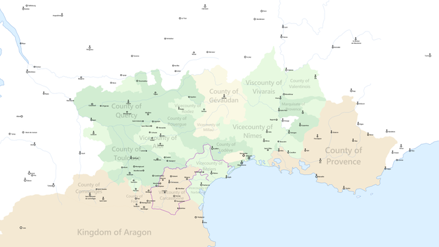
Languedoc at the beginning of the Albigensian Crusade
Summary
edit
| Warning | The original file is very high-resolution. It might not load properly or could cause your browser to freeze when opened at full size. |
|---|
| Description |
English: Languedoc at the beginning of the Albigensian Crusade, Purple Outline represents territories of Simon de Montfort in 1209 |
| Date | |
| Source | [1][2][3][4] |
| Author | Aldan-2 |
![[1]](https://upload.wikimedia.org/wikipedia/commons/a/a6/Map_France_1180-fr.svg)
![[2]](https://upload.wikimedia.org/wikipedia/commons/f/fa/Cartes_Occitanie.png)
![[3]](https://legacy.lib.utexas.edu/maps/historical/shepherd_1911/shepherd-c-069.jpg)
Licensing
edit
I, the copyright holder of this work, hereby publish it under the following license:
This file is licensed under the Creative Commons Attribution-Share Alike 4.0 International license.
- You are free:
- to share – to copy, distribute and transmit the work
- to remix – to adapt the work
- Under the following conditions:
- attribution – You must give appropriate credit, provide a link to the license, and indicate if changes were made. You may do so in any reasonable manner, but not in any way that suggests the licensor endorses you or your use.
- share alike – If you remix, transform, or build upon the material, you must distribute your contributions under the same or compatible license as the original.
File history
Click on a date/time to view the file as it appeared at that time.
| Date/Time | Thumbnail | Dimensions | User | Comment | |
|---|---|---|---|---|---|
| current | 00:29, 13 May 2019 | | 20,000 × 11,250 (5 MB) | Aldan-2 (talk | contribs) | User created page with UploadWizard |
You cannot overwrite this file.
File usage on Commons
The following page uses this file:
File usage on other wikis
The following other wikis use this file:
- Usage on ca.wikipedia.org
- Usage on cs.wikipedia.org
- Usage on en.wikipedia.org
- Usage on fa.wikipedia.org
- Usage on he.wikipedia.org
- Usage on sl.wikipedia.org
- Usage on zh.wikipedia.org