File:Lasithi Banner.jpg

Size of this preview: 798 × 114 pixels. Other resolutions: 320 × 46 pixels | 640 × 91 pixels | 1,024 × 146 pixels | 1,280 × 183 pixels | 9,044 × 1,292 pixels.
Original file (9,044 × 1,292 pixels, file size: 3.91 MB, MIME type: image/jpeg)
Captions
Captions
Add a one-line explanation of what this file represents
Summary edit
| Description |
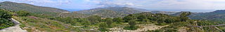
English: The region between Kalamafka and Prina is the only locality of Crete, where one can see both the Aegean Sea in the North (left) and the Libyan Sea in the South (right). On the southern coast is situated Ierapetra, the southernmost town of Europe. Deutsch: Die Region zwischen Kalamafka und Prina ist die einzige Stelle Kretas, von wo aus man sowohl die Ägäis im Norden (links) wie auch die Libysche See im Süden (rechts) sehen kann. An der Südküste liegt Ierapetra, die südlichste Stadt Europas. Ελληνικά: Η περιοχή είναι η μοναδική που μπορεις να βλέπεις το Αιγαίο και το Λυβικό πέλαγος ταυτόχρονα. Στην νότια πλευρά βρίσκεται η Ιεράπετρα. |
| Date | |
| Source | Crete Panorama.jpg |
| Author | H. Zell |
Licensing edit
This file is licensed under the Creative Commons Attribution-Share Alike 3.0 Unported license.
- You are free:
- to share – to copy, distribute and transmit the work
- to remix – to adapt the work
- Under the following conditions:
- attribution – You must give appropriate credit, provide a link to the license, and indicate if changes were made. You may do so in any reasonable manner, but not in any way that suggests the licensor endorses you or your use.
- share alike – If you remix, transform, or build upon the material, you must distribute your contributions under the same or compatible license as the original.
File history
Click on a date/time to view the file as it appeared at that time.
| Date/Time | Thumbnail | Dimensions | User | Comment | |
|---|---|---|---|---|---|
| current | 02:51, 15 November 2014 | 9,044 × 1,292 (3.91 MB) | Handrian (talk | contribs) | User created page with UploadWizard |
You cannot overwrite this file.
File usage on Commons
There are no pages that use this file.
File usage on other wikis
The following other wikis use this file: